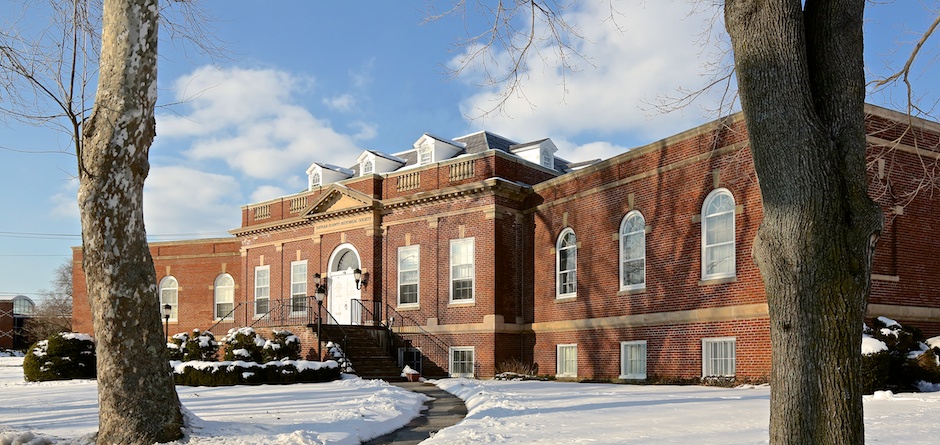
![]() PHOTO OF THE WEEK, 2015
PHOTO OF THE WEEK, 2015
The Suffolk County Historical Society’s Photo of the Week is created by our librarian, Wendy Polhemus-Annibell, using historic materials from our local history library’s extensive and varied archives. SCHS Photo of the Week is available by subscription only. Please email wannibell@schs-museum.org to subscribe.
MEMBERSHIP
We invite you to join the Suffolk County Historical Society, founded in 1886. Our museum exhibits, educational programs, and local history archives reflect and document Suffolk County’s rich history. www.suffolkcountyhistoricalsociety.org/membership.html
—————————————————————
PHOTO OF THE WEEK: December 18, 2015 — FROM THE SCHS LIBRARY ARCHIVES
“How shall we know it is us without our past?”
– John Steinbeck
Happy Holidays!
by Wendy Polhemus-Annibell, Librarian
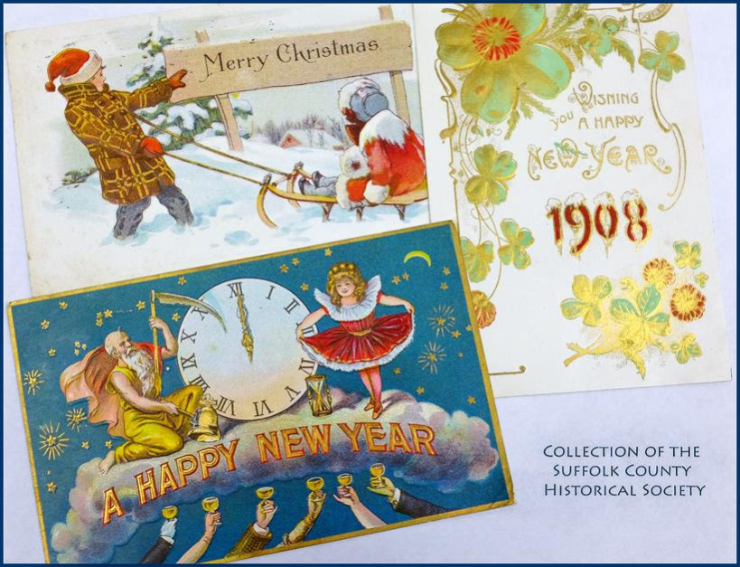 Assorted Holiday Cards From the One-Cent Postcard Era of the Early 20th Century. Selections from the Holiday Postcard Collection of the Suffolk County Historical Society Library Archives. Copyright Suffolk County Historical Society.
~~~~~~~~~~~~~~~~~~~~~~~~~~~~~~~~~~~~~~~~~~
Happy Holidays from the Suffolk County Historical Society to all our friends and supporters!
Holiday Closure: We will be closed December 25 to January 1.
——————————
SCHS Photo of the Week: Click Here to Visit Webpage.
Visit: www.suffolkcountyhistoricalsociety.org
To view 2014 Photo of the Week pages click here.
_________________________________________________________
PHOTO OF THE WEEK: December 11, 2015 — FROM THE SCHS LIBRARY ARCHIVES
“How shall we know it is us without our past?”
– John Steinbeck
Portrait of William Floyd
by Wendy Polhemus-Annibell, Librarian
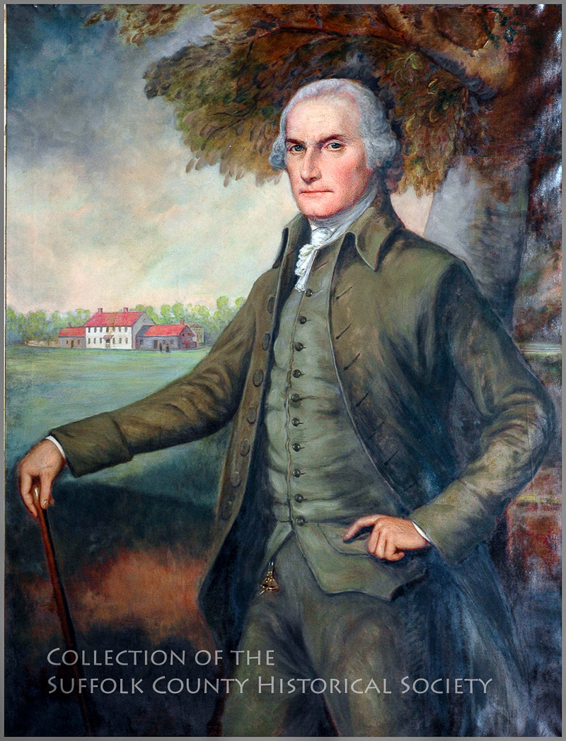
Portrait of William Floyd (1734-1821) by Ralph Earl, 1793, Oil on canvas reproduction. From the Collection of the Suffolk County Historical Society. Copyright Suffolk County Historical Society.
While in Connecticut during the 1790s, the artist Ralph Earl (1751-1801) made occasional trips to Long Island. His most important commission was for a portrait of Colonel William Floyd, a signer of the Declaration of Independence and a member of a wealthy Long Island family. The son of Nicoll Floyd and Tabitha Smith Floyd, William became a major land proprietor at age 20 when he inherited the family’s 4,400-acre estate in Brookhaven Town. Colonel William Floyd spent seventeen years in public service, as a Delegate to the Continental Congress, as a New York State Senator, and as a Representative to the U.S. Congress. Earl placed Floyd standing before his home in Mastic, thought to be built in 1724. Today the property is known as the William Floyd Estate.
Join us on Saturday, February 20, 2016, 1:00 PM, for a Book & Bottle presentation with MaryLaura Lamont on the fascinating History of the William Floyd Estate and the Floyd family. The event is open to all and includes wine, cheese, and admission to current exhibits (including this portrait of William Floyd!). Members free; Non-Members $5. RSVP requested: 631-727-2881 x107.
———————————————-
The Suffolk County Historical Society’s PHOTO OF THE WEEK Series is created by librarian Wendy Polhemus-Annibell using historic primary source materials from our local history library’s extensive archives. To subscribe, visit our website or send an email request to Wendy at wannibell@schs-museum.org.
——————————
SCHS Photo of the Week: Click Here to Visit Webpage.
Visit: www.suffolkcountyhistoricalsociety.org
To view 2014 Photo of the Week pages click here.
_________________________________________________________
PHOTO OF THE WEEK: December 4, 2015 — FROM THE SCHS LIBRARY ARCHIVES
“How shall we know it is us without our past?”
– John Steinbeck
Lady Golfers at Shinnecock Links, Southampton
by Wendy Polhemus-Annibell, Librarian
[To view Fullerton photograph, please here] Lady Golfers at Shinnecock Hills Links, 1901, by Hal B. Fullerton. (Image from the Harry T. Tuthill Fullerton Collection of the Suffolk County Historical Society Library Archives [149.7.42]. Copyright © Suffolk County Historical Society. All rights reserved.)
Shinnecock Hills Links in Southampton, today known as Shinnecock Hills Golf Club, is the oldest incorporated golf club in the country (1891), granting women full membership from the start. It is also the first golf club to admit women players, and is said to have the oldest clubhouse, built in 1892. In 1893, a popular nine-hole ladies-only course was designed and built at Shinnecock Hills:
“The Shinnecock Club is the only one having two separate courses, the long eighteen-hole course being known as the white course, and used exclusively by the men, while the other course of nine holes is termed the red course, and is used by the ladies” (New York Times, 1896).
The New York Times described Shinnecock Hills as “probably the most perfect golf course in this country” because of “the excellence of the links and the great amount of care and money that has been expended upon them” (1896). Added to the National Register of Historic Places in 2000, Shinnecock Hills has hosted the U.S. Open four times–in 1896, 1986, 1995, and 2004–and is scheduled to host again in 2018.
——————————
SCHS Photo of the Week: Click Here to Visit Webpage.
Visit: www.suffolkcountyhistoricalsociety.org
To view 2014 Photo of the Week pages click here.
_________________________________________________________
PHOTO OF THE WEEK: November 26, 2015 — FROM THE SCHS LIBRARY ARCHIVES
“How shall we know it is us without our past?”
– John Steinbeck
Historic Aldrich House (c. 1870 – 2015), Aquebogue
by Wendy Polhemus-Annibell, Librarian
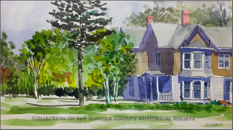
Copyright Suffolk County Historical Society. Double Bays, Watercolor, by Bernard Springsteel. (From the Collection of the Suffolk County Historical Society.)
In this lovely painting by Bernie Springsteel titled Double Bays, we see the artist’s rendition of the historic Aldrich house on Main Road in Aquebogue, which was demolished just a few months ago (see recent news story here). In spite of the structure’s deterioration over the years, its never-fading beauty hinted to passersby that this nearly 145-year-old house was at one time a work of architectural wonder. That’s because it was built by local master carpenter John Elliot Aldrich in the early 1870s, a celebrated builder of “costly country homes.”
Aldrich was born in Riverhead on March 22, 1842. His name appears in the Civil War Draft Registration Records (1863-1865), where he reported his age as 21, his profession as “carpenter,” and his location as “Upper Aquebogue.” He married Frances Fournier of Southampton in 1867, and together they had four children. According to an 1890 article in the Long-Islander, Mr. Aldrich was “doing business on a large scale,” contracting “to build thirty-five houses of various kinds from Flushing to Sag Harbor.” Mr. Aldrich died in 1906 and is buried in the Aquebogue Cemetery, not far from where the magnificent Main Road home depicted here stood from the 1870s to 2015.
_______________________
The Suffolk County Historical Society’s staff and board wish all of you a wonderful Thanksgiving holiday. SCHS will be closed Nov, 26-28 and will reopen on Wednesday, Dec. 2.
——————————
SCHS Photo of the Week: Click Here to Visit Webpage.
Visit: www.suffolkcountyhistoricalsociety.org
To view 2014 Photo of the Week pages click here.
_________________________________________________________
PHOTO OF THE WEEK: November 20, 2015 — FROM THE SCHS LIBRARY ARCHIVES
“How shall we know it is us without our past?”
– John Steinbeck
Gardiner’s Island: A Visit with Robert David Lion Gardiner, 1979
by Wendy Polhemus-Annibell, Librarian
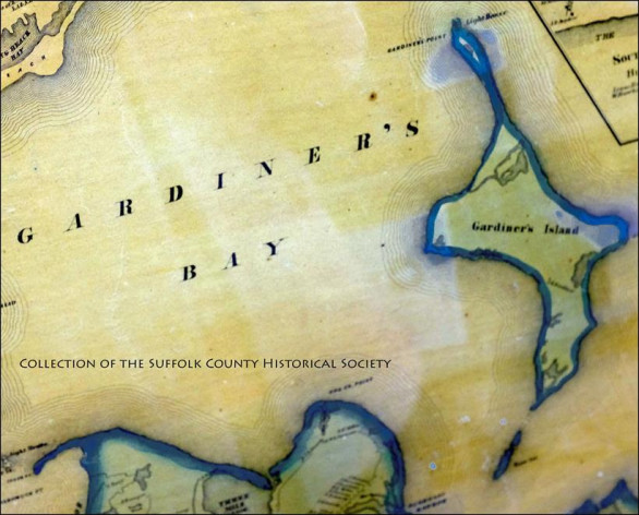
Gardiner’s Island is rich with history that dates back to the colonial days of America. It all started in 1639, when the island was settled by Lion Gardiner. According to Robert David Lion Gardiner in the film Gardiner’s Island: A Visit with Robert David Lion Gardiner (1979), Lion Gardiner acquired the property first by deed from the Montaukett Indians for “a large black dog, some powder and shot, and a few Dutch blankets,” and then by a grant from King Charles I. The island has been privately owned for over three hundred years by Lion Gardiner’s descendants, and is the only property in the United States still intact as part of an original royal grant, Mr. Gardiner tells us in the film.
You can now see and hear Robert David Lion Gardiner’s complete history and tour of the island online. The Suffolk County Historical Society has restored Gardiner’s Island: A Visit with Robert David Lion Gardiner, and the film can be viewed at our YouTube page.
The restoration of this historic film was made possible by the Robert David Lion Gardiner Foundation (www.rdlgfoundation.org).
SOURCES AND SUGGESTED READINGS: Lion Gardiner, The Papers and Biography of Lion Gardiner, 1599-1663, edited by Curtiss C. Gardiner, 1883. Colonial Dames of America, Pages in Azure and Gold: The Letters of Miss Gardiner and Miss Quincy, 1915. Robert David Lion Gardiner website. Gardiner’s Island: A Visit with Robert David Lion Gardiner (Fenwick Productions, 1979). https://www.youtube.com/channel/UCtFTIauIZTSMuUftfJuktSg.
——————————
SCHS Photo of the Week: Click Here to Visit Webpage.
Visit: www.suffolkcountyhistoricalsociety.org
To view 2014 Photo of the Week pages click here.
_________________________________________________________
 Copyright Suffolk County Historical Society
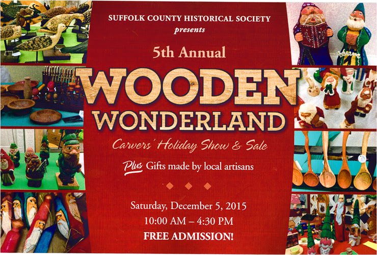
5th ANNUAL WOODEN WONDERLAND
Saturday, December 5, 2015
10:00 AM – 4:30 PM
FREE ADMISSION! FUN FOR THE WHOLE FAMILY!
Join us for our special holiday event, our 5th Annual Wooden Wonderland – Carvers’ Holiday Show & Sale! Featuring hand-crafted carvings, wooden items, and assorted gifts handmade by local artisans PLUS live woodcarving and woodworking demonstrations.
See our historic building come to life in a magnificent display of holiday arts and crafts, ornaments, home decor, rustic Santas and gnomes, wood carvings, and other one-of-a-kind locally made gifts! There’s something for everyone on your list!
————
 Copyright © 2015 Suffolk County Historical Society. All rights reserved. No part of this document may be reproduced in any form without the written permission of the Suffolk County Historical Society.
—————————-
SCHS Photo of the Week: Click Here to Visit Webpage.
Visit: www.suffolkcountyhistoricalsociety.org
To view 2014 Photo of the Week pages click here.
_________________________________________________________
PHOTO OF THE WEEK: November 6, 2015 — FROM THE SCHS LIBRARY ARCHIVES
On Veterans Day, let us remember and honor the service and sacrifices of our veterans.
The Rough Riders in Montauk, 1898
by Wendy Polhemus-Annibell, Librarian
To view this Harry T. Tuthill Fullerton photo, please visit the Suffolk County Historical Society, see link below: Rough Riders at Camp Wikoff, Montauk, 1898. (Image from the Harry T. Tuthill Fullerton Collection of the Suffolk County Historical Society Library Archives. Copyright © Suffolk County Historical Society. All rights reserved).
The most famous of all the units fighting in the Spanish-American War (1898), the “Rough Riders” was the name given to the First U.S. Volunteer Cavalry under the leadership of Theodore Roosevelt. Roosevelt resigned his position as Assistant Secretary of the Navy in May 1898 to join the volunteer cavalry. The original plan for this unit called for filling it with men from the Indian Territory, New Mexico, Arizona, and Oklahoma. However, once Roosevelt joined the group, it quickly became the place for a mix of troops ranging from Ivy League athletes to Texas Rangers and Indians.
Camp Wikoff in Montauk became a temporary home for the Rough Riders and more than twenty thousand other soldiers of the Army’s Fifth Corps when they were quarantined after fighting the Spanish in Cuba. During their stay at the huge camp, which was spread over much of Montauk, the men recovered from battle wounds, yellow fever, malaria, and typhoid. The Montauk camp was named in honor of Col. Charles A. Wikoff, commander of the 22nd U.S. Infantry, who was the first officer killed in the war.
—————————-
SCHS Photo of the Week: Click Here to Visit Webpage.
Visit: www.suffolkcountyhistoricalsociety.org
To view 2014 Photo of the Week pages click here.
_________________________________________________________
PHOTO OF THE WEEK: October 30, 2015 — FROM THE SCHS LIBRARY ARCHIVES
“How shall we know it is us without our past?”
– John Steinbeck
Happy Halloween!
by Wendy Polhemus-Annibell, Librarian
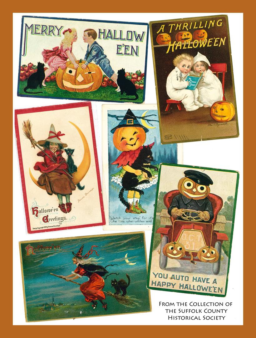
Halloween Postcards, Early 1900s. (Image collage created from the Holiday Postcard Collection of the Suffolk County Historical Society Library Archives. Copyright Suffolk County HIstorical Society. All rights reserved.)
Ghosts and goblins, spooks galore
Scary witches at your door
Jack-o-lanterns smiling bright
Wishing you a Haunting Night!
Click here for an interesting educational video, The History of Halloween, on the origins of the holiday.
The Suffolk County Historical Society wishes you and yours a happy and safe Halloween!
—————————-
SCHS Photo of the Week: Click Here to Visit Webpage.
Visit: www.suffolkcountyhistoricalsociety.org
To view 2014 Photo of the Week pages click here.
_________________________________________________________
PHOTO OF THE WEEK: October 23, 2015 — FROM THE SCHS LIBRARY ARCHIVES
“How shall we know it is us without our past?”
– John Steinbeck
Aerial View of Riverhead, c. 1938
by Wendy Polhemus-Annibell, Librarian
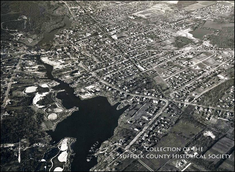
Aerial View of Riverhead, c. 1938. (Image from the Riverhead Pictorial Collection of the Suffolk County Historical Society Library Archives. Copyright Suffolk County HIstorical Society. All rights reserved.)
The Town of River Head was created on March 13, 1792, when the New York State Legislature officially divided it from the Town of Southold:
“WHEREAS, many of the freeholders and inhabitants of Southold…have represented to the Legislature that their town is so long, that it is very inconvenient for them to attend town meetings and…to transact the other necessary business of the said town; and have prayed that the same may be divided into two towns.”
This followed a petition by “Peter Reeves and others” seeking the separation from Southold, which was ultimately approved despite requests by “John Wells and other Justices of the Peace and other inhabitants of Southold” that the action be held over until the next meeting of the Legislature.
“THEREFORE, Be it enacted by the People of the State of New York…that all that part of the said Town of Southold lying to the westward of a line beginning at the Sound and running thence southerly to the Bay…and which is the eastern boundary or side of a farm now in the tenure of William Albertson and is the reputed line of division between the parishes of Ocquebogue and Mattituck shall…be erected into a distinct and separate town by the name of River Head.”
Up until this historic moment, the area known thereafter as the Town of River Head had flourished in colonial fashion as the western portion of the Town of Southold, which had been settled in 1640, and which had included Shelter Island and other islands, and all the North Shore of Long Island from Orient Point to Wading River.
SUGGESTED READINGS
Seeking the Past: Writings from 1832-1905 Relating to the History of the Town of Riverhead, edited by Tom Twomey (Newmarket Press, 2004).
Pioneers of Riverhead Town, compiled by Virginia Wines (Suffolk County Historical Society, 1981).
History of the Town of Riverhead, Suffolk County, N.Y., by Hon. George Miller, 1876.
The Riverhead Story: 1792-1967. Town of Riverhead, 1967.
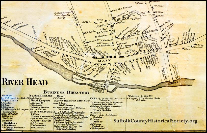
Downtown River Head portion of the Chace Map, 1858, in the library of the Suffolk County HIstorical Society. Photo by Wendy Polhemus-Annibell.
—————————-
SCHS Photo of the Week: Click Here to Visit Webpage.
Visit: www.suffolkcountyhistoricalsociety.org
To view 2014 Photo of the Week pages click here.
_________________________________________________________
PHOTO OF THE WEEK: October 16, 2015 — FROM THE SCHS LIBRARY ARCHIVES
“How shall we know it is us without our past?”
—– John Steinbeck
National Society of the Daughters of the Revolution (D of R), 1891-1983
by Wendy Polhemus-Annibell, Librarian
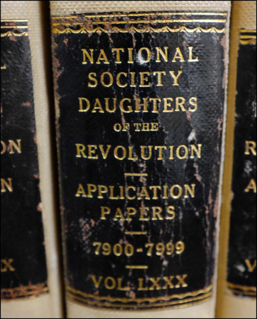 The National Society of the Daughters of the Revolution (D of R), 1891-1983. (Image from the Collection of the Suffolk County Historical Society Library Archives, the official D of R repository.) Photo by Wendy Polhemus-Annibell (2015)
The National Society of the Daughters of the Revolution (known as the “D of R”) was organized in 1891 after a difference of opinion within the Daughters of the American Revolution (DAR) arose over membership qualifications. The D of R was incorporated under the laws of the State of New York as an organization national in its work and purpose. The objectives of the society were stated in its constitution:
“To perpetuate the patriotic spirit of the men and women who achieved American Independence; to commemorate prominent events connected with the War of the Revolution; to collect, publish, and preserve the rolls, records, and historic documents relating to that period; to encourage the study of the country’s history; and to promote sentiments of friendship and common interest among the members of the Society.”
A woman was eligible for D of R membership if she was above the age of eighteen and was descended from an ancestor who “assisted in establishing American Independence during the War of the Revolution, as a military or naval officer, a soldier or a sailor, an official in the service of any of the thirteen original Colonies or of the United Colonies or States or of Vermont; a member of a committee of Correspondence or of Public Safety, or a recognized patriot who rendered material service in the cause of American Independence.”
When the National Society of the Daughters of the Revolution disbanded in 1983, the Suffolk County Historical Society became the official repository of the D of R’s national membership records and other materials. Though the collection has not been digitized, an invaluable electronic finding aid is available on the website of the German Genealogy Group (www.germangenealogygroup.com). These records, which contain a wealth of genealogical information, are available for viewing in our library archives during operating hours (Weds. – Sat., 12:30 – 4:30 pm). Come take a look! You never know what historic surprises you might find!
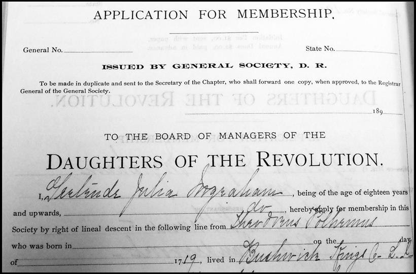
Portion of D of R Application #191, filed in 1892 by Gertrude Julia Ingraham, who “being of eighteen years and upwards, does hereby apply for membership in the Society by right of lineal descent from Theodorus Polhemus who was born in 1719 and lived in Kings County, Long Island.” (From the Collection of the Suffolk County Historical Society Library Archives.)
—————————-
SCHS Photo of the Week: Click Here to Visit Webpage.
Visit: www.suffolkcountyhistoricalsociety.org
To view 2014 Photo of the Week pages click here.
_________________________________________________________
PHOTO OF THE WEEK: October 9, 2015 — FROM THE SCHS LIBRARY ARCHIVES
“How shall we know it is us without our past?”
– John Steinbeck
The Suffolk County Seal, 1784
by Wendy Polhemus-Annibell, Librarian
Photo by Wendy Polhemus-Annibell (2015)
The Suffolk County Seal, 1784 (reproduction). (From the Collection of the Suffolk County Historical Society Library Archives.)
Suffolk County was founded in 1683. The first version of the Suffolk County Seal was made in 1784 by Elias Pelletreau, a noted Southampton silversmith and an ancestor of Judge Robert S. Pelletreau, a Surrogate of Suffolk County for many years. Elias Pelletreau noted in an account book that he was instructed by the Suffolk County Board of Supervisors to “make a seal for Suffolk County…the bigness of a half-dollar…in the figure an ox. Motto–‘Suffolk County Seal–Freedom and Independence’ with a socket on the top for a handle.” This seal was delivered to County Clerk Ezra L’Hommedieu, who paid for it and was reimbursed in the sum of two pounds by the Board of Supervisors in 1784. The whereabouts of the original seal by Pelletreau are unknown today.
In 1913, a certificate was filed with the Secretary of State and the Suffolk County Clerk (who is the official custodian of the county seal), indicating that a new seal would be made and be represented by a wreath within a circle accompanied by the words “Suffolk County Seal.” In 1938, however, the Board of Supervisors ordered the County Historian, Morton Pennypacker, to redesign the seal by reverting back to the original seal containing the figure of an ox. There is no official explanation of the symbolism behind the ox, though it’s often been claimed that it represents Suffolk County’s agricultural heritage.
Suggested Readings: The Great Seal of the State of New York, the Seal of Suffolk County, and the Seals of the Ten Towns, compiled by George L. Weeks Jr., the Suffolk County Historian, in cooperation with the Town Historians and the Suffolk County Historical Society, 1976. “History of the Suffolk County Seal,” by Ruth S. Hague, Deputy Clerk, Suffolk County Board of Supervisors, 1960.
—————————-
SCHS Photo of the Week: Click Here to Visit Webpage.
Visit: www.suffolkcountyhistoricalsociety.org
To view 2014 Photo of the Week pages click here.
_________________________________________________________
PHOTO OF THE WEEK: October 2, 2015 — FROM THE SCHS LIBRARY ARCHIVES
“How shall we know it is us without our past?”
– John Steinbeck
The Wickham Murders Axe
by Wendy Polhemus-Annibell, Librarian
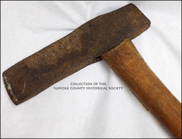
The Wickham Murders Axe. (From the Collection of the Suffolk County Historical Society Museum Archives.) This post hole axe used in the murder of the Wickham family at Cutchogue on June 2, 1854, was donated to the Suffolk County Historical Society 110 years ago. Photo by Wendy Polhemus-Annibell (2015)
In 1851, James and Frances Wickham, a retired couple from New York City, purchased a 60-acre farm in Cutchogue, Long Island, and soon after hired several servants—a young African American, Stephen Winston, and two young women from Ireland, Ellen Holland and Catherine Dowd. Ellen and Catherine shared the attic space as their living quarters in the Wickham home. Later, with the farm requiring still more help, James Wickham arranged for the employment of Nicholas Behan from NYC through the Emigrant Labor Exchange program.
Within a short period of time, Nicholas made several attempts to court Ellen Holland and complaints against him were quickly lodged by both Ellen and Catherine. In the spring of 1854, when Frances Wickham confronted Nicholas with the girls’ complaints, his temper became apparent and the Wickhams decided that Nicholas was not working out as planned. James Wickham attempted to sever the relationship between Nicholas and the Wickham farm by paying him directly as well as by settling a substantial outstanding local debt that was owed by Nicholas.
Now out of a job, Nicholas moved to Greenport. But after midnight on June 2, 1854, he returned to the Wickham farm in Cutchogue to commit a gruesome attack on the family. Nicholas grabbed an axe from the Wickham’s shed, entered the home through a kitchen window, walked right past the family dog, and attacked the young boy Stephen, fatally injuring him. Then Nicholas found James and Frances Wickham in their bedroom and bludgeoned both of them to death. From the attic, Ellen and Catherine heard the commotion and escaped out of an upstairs window.
At the trial, all of the evidence led to the conviction of Nicholas Behan, who became one of the last people to be hanged in Suffolk County. The axe used in the murder was obtained from George Edwards, son of the jailer Daniel Edwards, at the time of the trial and was presented to the Suffolk County Historical Society in 1906 by Septer Luce. The farm in Cutchogue is today still owned and operated by the Wickham family.
Suggested Reading: Murder on Long Island: A Nineteenth-Century Tale of Tragedy and Revenge, by Geoffrey Fleming and Amy Folk. Southold Historical Society, 2013. This book is available for purchase in our Weathervane Bookshop!
—————————-
SCHS Photo of the Week: Click Here to Visit Webpage.
Visit: www.suffolkcountyhistoricalsociety.org
To view 2014 Photo of the Week pages click here.
_________________________________________________________
PHOTO OF THE WEEK: Sept. 25, 2015 — FROM THE SCHS LIBRARY ARCHIVES
“How shall we know it is us without our past?”
– John Steinbeck
The Famous Long Island Potato
by Wendy Polhemus-Annibell, Librarian
 The Famous Long Island Potato (on a Long Island Railroad Train). (Postcard image from the Riverhead Pictorial Collection [202.29.137]. Copyright © Suffolk County Historical Society. All rights reserved.)
Long Island has a long history with potatoes dating back to the 1800s. Potato production peaked in the late 1940s with over 70,000 acres grown on the island by many hundreds of potato farmers. Due to the heavy potato production on Long Island, in 1963 the Potato Association of America held its 50th Anniversary celebration at the Perkins Hotel in Riverhead.
Long Island horticulturalist Edith Loring Fullerton explained in How to Make a Vegetable Garden (Doubleday, 1905) that the best potato crop is obtained by planting sections of the potato that have three eyes, but that “some Englishmen argue the finest crop comes from planting whole, medium-sized tubers.” She experimented with both methods in the early 1900s at the LIRR’s experimental farms in Wading River and Medford, finding that “the whole potatoes sent up more shoots five days sooner, were handsomer, and equally as strong as those from the cut sections.” However, the yield from the cut potatoes was 35 pounds versus only 28 pounds for the whole tubers (both were planted in short rows of equal length). The average size was nearly equal, but the whole tubers yielded ripe potatoes almost two weeks sooner than the cut sections. Favorite potato varieties on Long Island at the turn of the twentieth century were Green Mountain, Rural New Yorker, Early Rose, and Gold Coin.
——————————————————————————————————
 Book & Bottle on History of LI Food
A History of Long Island Food will be the focus of a BOOK & BOTTLE talk and book signing with Edible Long Island food writer Tom Barritt on Saturday, October 24, 2015 – 1:00 PM at the Suffolk County Historical Society. $5 Non-Members / Members Free. RSVP Requested: 631-727-2881 x106.
~~~~~~~~~~~~~~~~~~~~
MEMBERSHIP DRIVE
If you’ve been enjoying our Photo of the Week, please consider becoming a member of SCHS.
From the Civil War to civil rights, revolutions to restorations, spies to Suffragettes, boatbuilders to bootleggers, and whalers to wineries, Long Island’s history comes alive at the Suffolk County Historical Society!
——————————————————
SCHS Photo of the Week: Click Here to Visit Webpage.
Visit: www.suffolkcountyhistoricalsociety.org
To view 2014 Photo of the Week pages click here.
_________________________________________________________
PHOTO OF THE WEEK: Sept. 11, 2015 — FROM THE SCHS LIBRARY ARCHIVES
“How shall we know it is us without our past?”
– John Steinbeck
The 1938 Hurricane
by Wendy Polhemus-Annibell, Librarian
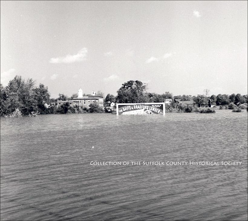
Aftermath of the 1938 Hurricane, Westhampton. Submerged in tidal surge waters is a “Davis & Bradford Lumber Co.” billboard. (Image from the George D. Haddad Collection of the Suffolk County Historical Society [208.13.75]. Copyright © Suffolk County Historical Society. All rights reserved.)
According to eyewitness Captain Walter E. Budd, September of 1938 was just like any other September except that it had been unusually hot and humid. Labor Day came and went, and summer had ended. People went back to work or school and closed their summer homes. The seasonal evacuation of Long Island’s beaches turned out to be very fortunate. Captain Budd had his boat at Fire Island when the storm hit:
After about two hours of the worst wind I ever saw–I couldn’t believe what was happening! I saw big limbs off the trees blowing through the air along with parts of roofs and buildings. I saw blue herons and seagulls blown through the air like a bunch of feathers tumbling in all directions. Then, all at once the wind died out and that’s when I tried to get my anchor, only to find it was caught on the telephone cable that goes from Bay Shore to Saltaire. I hauled the anchor up and down, it was skidding along the cable for half a mile at least, the tide was coming in so strong. That’s when I saw that big mass of water come over the beach at Kismet, and the buildings were moving around like building blocks. I couldn’t believe what I was seeing. Later I learned this was the eye of the hurricane.
The 1938 Hurricane (also referred to as the Long Island Express) was one of the deadliest and most destructive hurricanes to impact the Northeast. The storm formed near the coast of Africa on September 9, becoming a Category 5 hurricane before making landfall as a Category 3 hurricane on Long Island on September 21. The hurricane was estimated to have killed 682 people and to have damaged or destroyed over 57,000 homes in the Northeast.
Eastern Long Island experienced some of the worst of the storm. The Dune Road area of Westhampton Beach was obliterated, resulting in 29 deaths. A cinema in Westhampton was swept two miles out to sea, and people at the matinee and the theater’s projectionist drowned. The storm surge temporarily turned Montauk into an island as it flooded across the South Fork at Napeague and obliterated the LIRR tracks. The surging water created the present-day Shinnecock Inlet by carving out a large section of barrier island separating the bay from the ocean. The storm toppled the landmark steeple of the tallest building in Sag Harbor, the Old Whaler’s Church. In Greenport, the storm blew down the movie theater located on Front Street.
———————————
MEMBERSHIP DRIVE
If you’ve been enjoying our Photo of the Week, please consider becoming a member of SCHS.
From the Civil War to civil rights, revolutions to restorations, spies to Suffragettes, boatbuilders to bootleggers, and whalers to wineries, Long Island’s history comes alive at the Suffolk County Historical Society!
The Suffolk County Historical Society, founded in 1886, collects and preserves the rich history of Suffolk County and beyond. We offer a history museum, art galleries, a research library and archives, and a multitude of exhibits, programs, and educational lectures and workshops year-round. Our unique collections reflect more than three centuries of Long Island history.

——————————————————
SCHS Photo of the Week: Click Here to Visit Webpage.
Visit: www.suffolkcountyhistoricalsociety.org
To view 2014 Photo of the Week pages click here.
_________________________________________________________
PHOTO OF THE WEEK: Sept. 11, 2015 — FROM THE SCHS LIBRARY ARCHIVES
“How shall we know it is us without our past?”
– John Steinbeck
The Fall Harvest, 1910
by Wendy Polhemus-Annibell, Librarian
To view Fullerton Photograph, please visit SCHS website. The Fall Harvest, 1910, by Hal B. Fullerton. (Image from the Harry T. Tuthill Fullerton Collection of the Suffolk County Historical Society [149.7.502]. Copyright © Suffolk County Historical Society. All rights reserved.)
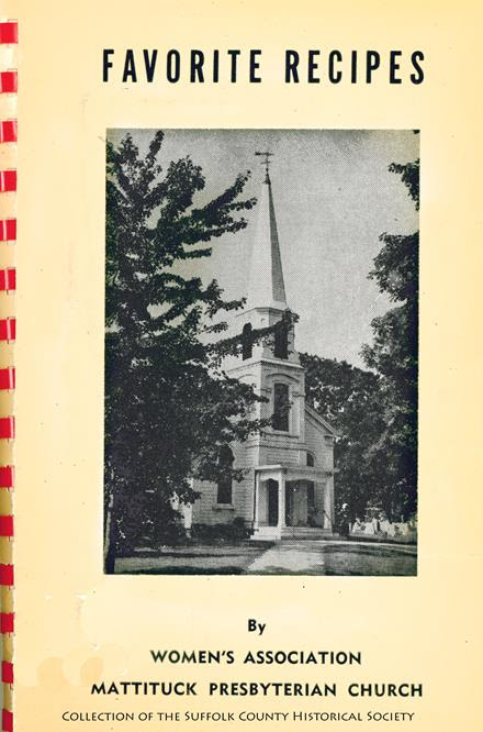
Autumn, the season of the harvest, is a time to gather nature’s bounty of fruits and vegetables, eat them with gratitude, and preserve them for the cold winter months. This week we feature a recipe for Pequash Clam Chowder from an old, yellowed (and undated) Favorite Recipes book by the Women’s Association of the Mattituck Presbyterian Church.
Pequash Clam Chowder
The following recipe for clam chowder is the same as that used at the Pequash Club of Cutchogue, L.I. At this old-time men’s club, the chowder is prepared in a large iron pot hung in an open fireplace just as it was 75 or more years ago.
1 peck hard clams
1-1/4 lb. salt pork
1/8 lb. butter
6 qt. potatoes, peeled and sliced paper thin
1/2 pt. stewed tomoatoes
3 or 4 large onions, peeled and ground
Cut salt pork into thin slices and fry out in bottom of large kettle. When finished, remove pork and add butter. Add tomatoes, ground onions, and a little water. Cook slowly for an hour. Add sliced potatoes and cook another hour. Open clams, saving meat and juice. Grind meat in chopper. Add meat and juice after second hour. If it appears too thick, add water. Cook for 40 minutes. Taste and add salt as desired. Contributed by Arthur Q. Tuthill.
——————————————————
SCHS Photo of the Week: Click Here to Visit Webpage.
Visit: www.suffolkcountyhistoricalsociety.org
To view 2014 Photo of the Week pages click here.
_________________________________________________________
PHOTO OF THE WEEK: Sept. 4, 2015 — FROM THE SCHS LIBRARY ARCHIVES
“How shall we know it is us without our past?”
– John Steinbeck
Main Street, Bellport, 1927
by Wendy Polhemus-Annibell, Librarian
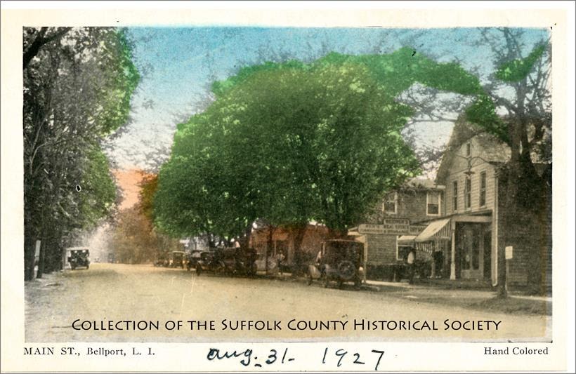
Main Street, Bellport, 1927. (Image from the Bellport Postcard Collection of the Suffolk County Historical Society. Copyright © Suffolk County Historical Society. All rights reserved.)
Bellport Village, located along the Great South Bay on the South Shore of Suffolk County, is sixty-five miles east of Manhattan, about halfway between New York City and Montauk Point. Founded as a seaport by Captains Thomas Bell and John Bell during the early nineteenth century, the village began as a modest outpost of farmers and seafarers. Most of the houses that still line Bellport Lane were built by sea captains; in fact, dozen of homes in the village are listed on the National Register of Historic Places. The village was named after the Bell brothers. By 1829, the brothers were building a deck into the bay and a shipyard, and carving out the streets of the village.
Bellport’s South Shore location was ideal for clamming and fishing, and for many years residents made a living off of the sea. With the eventual closure of the inlet, Bellport grew as a place for leisure and recreation. Enjoyed for both its beauty and recreational opportunities, visitors from New York City began to make Bellport Village their summer retreat. Among its visitors and admirers were some of the most prominent people in the social, business, and artistic worlds. E. B. White, inspired by his summer vacations in Bellport, wrote: “how well I know the bay and the way the wind blows, the tide ebbs, and the tide flows.”
Suggested Reading: Bellport: A Historic Community, by the Village of Bellport, 1976.
——————————————————
SCHS Photo of the Week: Click Here to Visit Webpage.
Visit: www.suffolkcountyhistoricalsociety.org
To view 2014 Photo of the Week pages click here.
_________________________________________________________
PHOTO OF THE WEEK: August 28, 2015 — FROM THE SCHS LIBRARY ARCHIVES
“How shall we know it is us without our past?” – John Steinbeck
Early Baseball Teams in Suffolk County
by Wendy Polhemus-Annibell, Librarian
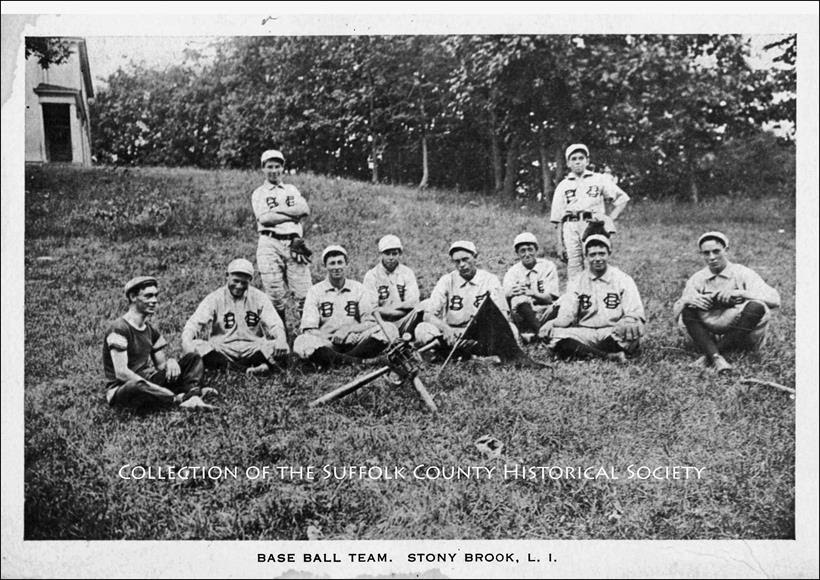
Stony Brook Baseball Team (undated postcard). Identified on the back of the postcard are these eight players (left to right): Stanley Jewall, Fred Darling, Ernest Bennett, Frank Jacinsky, Duane Squire, Chas Conklin, Leroy Norton, Chester Wood. (Image from the Brookhaven Pictorial Collection of the Suffolk County Historical Society [198.24.20]. Copyright © Suffolk County Historical Society. All rights reserved.)
Baseball’s popularity as a national pastime spread across Long Island in the years following the Civil War, when it was a game played primarily at county fairs and in farmers’ fields. One of the earliest games recorded in Suffolk County was played at the Suffolk County Fair in Greenport in 1867, when the well-known Huntington Suffolks won the prized Silver Ball. Another well-known team in Suffolk, the Hawkins Nine from Ronkonkoma, played from the 1890s to 1935 and included six Hawkins brothers: Samuel, Morris, E. Stansbury, Ernest, Charles, and Richard.
Leo Fishel (1877-1960) of Babylon played for a number of Suffolk County teams. He was one of the first players in the county to make it to Major League Baseball and was the first Jewish pitcher in the majors. In 1899, when Fishel was attending Columbia University, the New York Giants requested him to pitch against the Cleveland Indians. Although Fishel lost his only major league game, he did strike out six batters and even got a hit for his team.
Some other early Suffolk County baseball teams included the Oregons from Mattituck, the Babylon Seniors, the Project Nines from Bay Shore, the St. James Nines, the Riverhead Nines, and the Old Field Club, among others.
Suggested Readings: “Suffolk County Base Ball,” by Robert L. Harrison, SCHS Register, Vol. XXVII, No. 3; Baseball Hall of Fame (http://baseballhall.org/Learn/Education); Suffolk Sports Hall of Fame (http://www.suffolksportshof.com/#!about2/c4nz)
——————————————————
SCHS Photo of the Week: Click Here to Visit Webpage.
Visit: www.suffolkcountyhistoricalsociety.org
To view 2014 Photo of the Week pages click here.
_________________________________________________________
PHOTO OF THE WEEK: August 21, 2015 — FROM THE SCHS LIBRARY ARCHIVES
“How shall we know it is us without our past?” – John Steinbeck
Brentwood: Once a “Modern Times” Utopia
by Wendy Polhemus-Annibell, Librarian
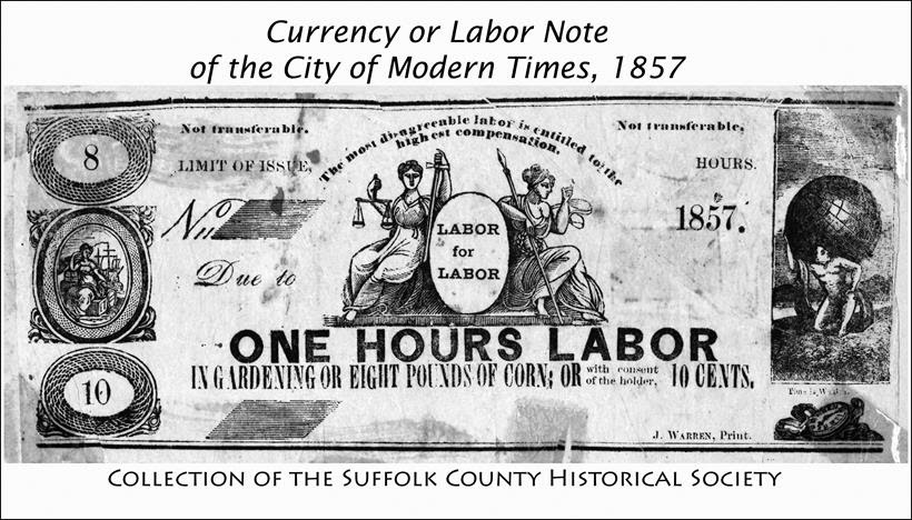
Brentwood–Once a “Modern Times” Utopia. Currency or Labor Note of the City of Modern Times, 1857: “One Hours Labor in Gardening or Eight Pounds of Corn….” (Image from the Modern Times, Brentwood Collection of the Suffolk County Historical Society Library Archives. Copyright © Suffolk County Historical Society. All rights reserved.)
From Positions Defined, by Josiah Warren, Founder of Modern Times: An impression is abroad…that the “Equity movement” is characterised by an unusual latitude in the Marriage relations–I as one, protest against this idea. ‘The sovereignty of every Individual” is as valid a warrant for retaining the present relations, as for changeing them; and it is equally good for refusing to be drawn into any controversies or even conversation on the subject. I find no warrant in my ‘sovereignty’ for invading, disturbing, or offending other people, whatever may be their sentiments or modes of life, while they act only at their own Cost, and would reiterate in the most impressive possible manner that the greatest characteristic of this movement is its “INDIVIDUALITY”–that the persons engaged in it are required to act entirely as INDIVIDUALS–not as a Combination or Organization. That we disclaim entirely, all responsibility for the acts, opinions, or reputations of each other. These principles of Equity are as broad as the universe, embracing every possible diversity of character. I therefore do not look for conformity, and therefore repudiate all combined or partnership responsibilities…. –Village of Modern Times, Aug. 1853
The “free love” utopian colony of Modern Times was founded in 1851 by Josiah Warren, a Boston-born reformer and nonviolent anarchist who advocated for the “sovereignty of the individual.” He purchased over 700 acres of land on the south side of the LIRR tracks in the area that is present-day Brentwood. He laid out streets and advertised for pioneers. The colony of 100 persons settled in the new village. They cleared the land, built log cabins, and planted large gardens that became their chief means of support. In 1857, the population of Modern Times had doubled to 200 colonists.
Accessible via “railway or rainbow,” Modern Times had a lifespan of about one decade. Under Warren’s leadership, it was probably “the most ideal utopia of any other community in the United States, if not the whole world,” according to Verne Dyson. Dishonesty, disorder, and crime were nonexistent; there were no policemen, no prisoners, no judges, no jail. The “Time Store,” a feature of Warren’s economy, worked effectively to provide all of the food, household necessities, and clothing the community needed at cost. The only money circulated in the colony were the labor notes printed by Warren in his print shop; they were not backed by gold or silver but by a specific number of hours of honest labor.
The colony of Modern Times, surrounded by the peaceful wilderness 40 miles east of New York City, seemed to have discovered the magic formula for peace in Plato’s Republic and Thomas More’s Utopia. But internal and external forces, including the economic panic of 1857 and the Civil War, combined to destroy the colony. Warren lamented that sensational newspaper accounts and troublemakers of various kinds began to invade and disturb the peace at Modern Times:
“One man began to advocate plurality of wives, and published a paper to support his views; another believed clothing to be a superfluity, and not only attempted to practice his Adamic theories in person, but imposed his views upon his hapless children. A woman with an ungainly form displayed herself in public in man’s attire, which gave rise to the newspaper comment: ‘The women dress in men’s clothing and look hideous’….”
Warren left Modern Times shortly before the name was changed to Brentwood in the troubled Civil War period, somewhat frustrated but faithful to his theories until the end of his life. His last years were spent in Boston and with friends in Princeton, Massachusetts. In the last letter he wrote before his death, Josiah Warren vowed that “a piece of land set apart for each person who desires it [is]…the first step in civilization.”
~~~~~~~~~~~~~~~~~~~~~~~
Suggested Readings
“Positions Defined,” by Josiah Warren, Village of Modern Times, August 1853.
“A Fleeting Moment in History…Modern Times,” by Verne Dyson. N.p., n.d.
“A Brief History of The City of Modern Times, Long Island, NY,” by Charles A. Codman, unpublished manuscript, c. 1900. Collection of the Suffolk County Historical Society.
____________________

MEMBERSHIP DRIVE
If you’ve been enjoying our Photo of the Week, please consider becoming a member of SCHS.
From the Civil War to civil rights, revolutions to restorations, spies to Suffragettes, boatbuilders to bootleggers, and whalers to wineries, Long Island’s history comes alive at the Suffolk County Historical Society!
The Suffolk County Historical Society, founded in 1886, collects and preserves the rich history of Suffolk County and beyond. We offer a history museum, art galleries, a research library and archives, and a multitude of exhibits, programs, and educational lectures and workshops year-round. Our unique collections reflect more than three centuries of Long Island history. Click here for Member Benefits!
——————————————————
SCHS Photo of the Week: Click Here to Visit Webpage.
Visit: www.suffolkcountyhistoricalsociety.org
To view 2014 Photo of the Week pages click here.
_________________________________________________________
PHOTO OF THE WEEK: August 14, 2015 — FROM THE SCHS LIBRARY ARCHIVES
“How shall we know it is us without our past?” – John Steinbeck
Huntington Harbor, East Shore, 1900
by Wendy Polhemus-Annibell, Librarian
(To view Fullerton Photo please visit SCHS webpage / link below) Huntington Harbor, East Shore, Sailboats at Anchor, 1900, by Hal B. Fullerton. (Image from the Harry T. Tuthill Fullerton Collection of the Suffolk County Historical Society Library Archives [149.7.78]. Copyright © Suffolk County Historical Society. All rights reserved.)
Huntington was founded in 1653 by three men from Oyster Bay who purchased a parcel of land from the Matinecock tribe. This parcel, which has since become known as the “First Purchase,” included land bordered by Cold Spring Harbor on the west, Northport Harbor on the east, what is now known as Old Country Road to the south, and Long Island Sound to the north. The men immediately turned the land over to the white settlers who had already been living there. From this initial settlement, Huntington grew over subsequent years to include all of the land presently comprising the modern Towns of Huntington and Babylon. It wasn’t until 1872 that the southern part of the town was formally separated to create Babylon Town.
Because Huntington was populated largely by English settlers, unlike the rest of the New Amsterdam colony, the town voted in 1660 to become part of the Connecticut colony rather than remain under the authority of New Amsterdam. When the British gained control of New Amsterdam in 1664 (renaming it “New York”), Huntington was formally restored to the jurisdiction of New York. Following the Battle of Long Island during the Revolutionary War, British troops used Huntington as their headquarters and remained encamped there until the end of the war.
When President George Washington visited Huntington in 1790, the town had 2,000 residents. Most lived in Huntington hamlet, with farmhouses scattered in the rest of the town. By the early 1800s, the town’s population had grown to over 4,000. The arrival of the Long Island Railroad in 1867 transformed the economy of Huntington from primarily agriculture and shipping (based on its well-protected harbor) to tourism and commuting. The end of World War II brought about an explosive growth of population in Huntington, where farms and resorts gave way to residential homes and businesses.
____________________

MEMBERSHIP DRIVE
If you’ve been enjoying our Photo of the Week, please consider becoming a member of SCHS.
From the Civil War to civil rights, revolutions to restorations, spies to Suffragettes, boatbuilders to bootleggers, and whalers to wineries, Long Island’s history comes alive at the Suffolk County Historical Society!
The Suffolk County Historical Society, founded in 1886, collects and preserves the rich history of Suffolk County and beyond. We offer a history museum, art galleries, a research library and archives, and a multitude of exhibits, programs, and educational lectures and workshops year-round. Our unique collections reflect more than three centuries of Long Island history.
——————————————————
SCHS Photo of the Week: Click Here to Visit Webpage.
Visit: www.suffolkcountyhistoricalsociety.org
To view 2014 Photo of the Week pages click here.
_________________________________________________________
PHOTO OF THE WEEK: August 7, 2015 — FROM THE SCHS LIBRARY ARCHIVES
“How shall we know it is us without our past?” – John Steinbeck
Old Field Lighthouse, 1933
by Wendy Polhemus-Annibell, Librarian
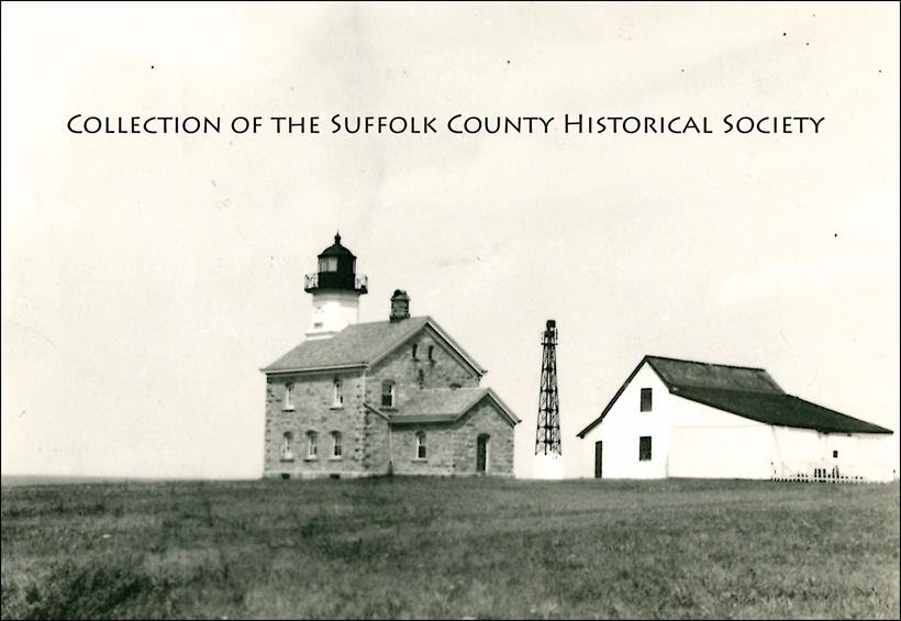
Old Field Lighthouse, 1933. (Image from the Brookhaven Pictorial Collection of the Suffolk County Historical Society Library Archives [182.117.11]. Copyright © Suffolk County Historical Society. All rights reserved.)
In 1822-1823, the U.S. Congress provided $4,000 for the construction of a lighthouse at Old Field Point near the entrance to Port Jefferson Harbor. The land was purchased from Samuel Thompson for $400. Construction of the 30-foot octagonal stone tower and separate 1-1/2-storey lightkeeper’s house was completed in 1824. The lighthouse had nine whale oil lamps that were arranged in a lantern and magnified with parabolic reflectors. Though the original lighthouse was rebuilt in the 1860s, the keeper’s house remains. Shortly after the Civil War, a new, 67-foot-tall lighthouse was built to accommodate the increased shipping traffic on Long Island Sound. Construction of this currently existing lighthouse was completed in 1869. Its Victorian-Gothic Revival style is similar to that of the Plum Island Lighthouse. Kerosene was first used to power the lamp, but today the electric unit flashes alternating red and green and has a range of 30 miles.
The Old Field Lighthouse was deactivated in 1933 and the property was conveyed to the Village of Old Field in 1935 for public-park purposes. After the bombing of Pearl Harbor in 1941, however, the government seized the station, along with Southold’s Horton Point Lighthouse, for purposes of national defense. Horton Point was manned by aircraft spotters, while a small Coast Guard contingent occupied Old Field Light. After the war, both lighthouses were returned to their respective communities.
According to Lighthouses of Long Island, Suffolk County has more lighthouses than any other county in the United States, and Southold Town has more lighthouses than any other town in the country. You can view the long list of Long Island’s lighthouses at this link: Long Island’s Lights.
~~~~~~~~~~~~~~~~~~~~~~~~~~
SUGGESTED READINGS
Harlan Hamilton, Lights and Legends: A Historical Guide to Lighthouses of Long Island Sound, Fishers Island Sound, and Block Island Sound (2006).
Lighthouse Friends: www.lighthousefriends.com/light
NYS Lighthouses: www.newyorklighthouses.com/oldfield.htm
____________________
MEMBERSHIP DRIVE
If you’ve been enjoying our Photo of the Week, please consider becoming a member of SCHS.
From the Civil War to civil rights, revolutions to restorations, spies to Suffragettes, boatbuilders to bootleggers, and whalers to wineries, Long Island’s history comes alive at the Suffolk County Historical Society!
The Suffolk County Historical Society, founded in 1886, collects and preserves the rich history of Suffolk County and beyond. We offer a history museum, art galleries, a research library and archives, and a multitude of exhibits, programs, and educational lectures and workshops year-round. Our unique collections reflect more than three centuries of Long Island history.
——————————————————
SCHS Photo of the Week: Click Here to Visit Webpage.
Visit: www.suffolkcountyhistoricalsociety.org
To view 2014 Photo of the Week pages click here.
_________________________________________________________
PHOTO OF THE WEEK: July 31, 2015 — FROM THE SCHS LIBRARY ARCHIVES
“How shall we know it is us without our past?” – John Steinbeck
Miller Place Rail Road Station, 1910
by Wendy Polhemus-Annibell, Librarian
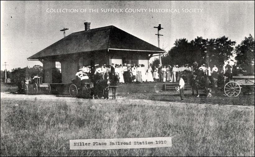
Miller Place Rail Road Station, 1910. (Image from the Brookhaven Pictorial Collection of the Suffolk County Historical Society Library Archives [207.00.169]. Copyright © Suffolk County Historical Society. All rights reserved.)
The land that Miller Place occupies today was purchased from the Setalcott Indians in 1664 by settlers of Setauket. The parcel also included what would become Mount Sinai. The first known dwelling in the area was constructed in the 1660s by Captain John Scott, though we do not know who occupied the home. Located on the eastern side of Mount Sinai Harbor, the home was one of several dwellings commissioned by Scott.
While the original settler of Miller Place is unknown, the settling of the region is accredited to the original Miller family. In 1679, an East Hampton settler named Andrew Miller purchased a 30-acre plot. Miller was a cooper by profession, and records indicate that he had emigrated from either England or Scotland.
By the early 1700s, the community had become known as Miller’s Place. The Miller family expanded well into the eighteenth century and continually developed houses in the northern part of the hamlet. The Millers were in time joined by members of such families as the Helmes, Robinsons, Burnetts, Hawkins, Woodhulls, and Thomases, among others. Many roads in the present-day hamlet of Miller Place are named after the area’s historic families.
——————————————————
SCHS Photo of the Week: Click Here to Visit Webpage.
Visit: www.suffolkcountyhistoricalsociety.org
To view 2014 Photo of the Week pages click here.
_________________________________________________________
PHOTO OF THE WEEK: July 24, 2015 — FROM THE SCHS LIBRARY ARCHIVES
“How shall we know it is us without our past?” – John Steinbeck
Camp Upton – World War II
by Wendy Polhemus-Annibell, Librarian
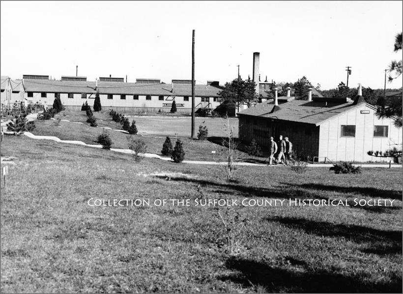
Camp Upton, October 1943. Looking north between the barracks, 4th receiving center area. (Image from the Camp Upton / World War II Pictorial Collection of the Suffolk County Historical Society Library Archives. Copyright © Suffolk County Historical Society. All rights reserved.)
The site on which the present-day Brookhaven National Laboratory now stands was originally an Army camp – Camp Upton, which was named after Emory Upton, a Union general in the Civil War. Located near Yaphank, in the heart of the Pine Barrens, Camp Upton was built in 1917 as an induction and training facility for the 30,000 soldiers who went on to fight in World War I. Between the world wars, the camp was used by members of the Civilian Conservation Corps, who planted many of the trees on the site. In 1940, on the eve of World War II, the camp was reopened, serving its original purpose as a military training ground. In 1944, Camp Upton was used as a hospital to treat wounded veterans of the war. It also served as a prisoner of war camp, when in 1945, five hundred German prisoners were sent to Camp Upton. In 1947, the camp was replaced by Brookhaven National Laboratory.
——————————————————
SCHS Photo of the Week: Click Here to Visit Webpage.
Visit: www.suffolkcountyhistoricalsociety.org
To view 2014 Photo of the Week pages click here.
_________________________________________________________
PHOTO OF THE WEEK: July 17, 2015 — FROM THE SCHS LIBRARY ARCHIVES
“How shall we know it is us without our past?” – John Steinbeck
Suffolk County Fair Grounds, Riverhead, 1898
by Wendy Polhemus-Annibell, Librarian
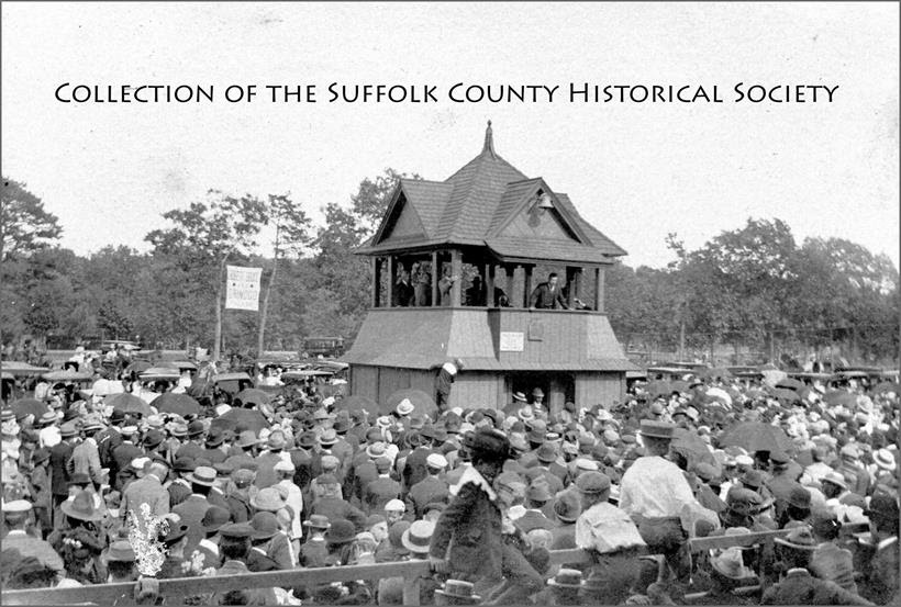
Col. Theodore Roosevelt at the Suffolk County Fair During His Campaign for Governor, Riverhead Fair Grounds, 1898. Roosevelt is standing on the Starting Tower, which was used for trotting races and many other popular events at the Riverhead Fair Grounds. (Image from the Orville Young Pictorial Collection of the Suffolk County Historical Society Library Archives. Copyright © Suffolk County Historical Society. All rights reserved.)
The Suffolk County Fair took place for nearly a hundred years, from the 1840s thru most of the 1930s, and was organized by the Suffolk County Agricultural Society. The Society’s Fair Grounds at Riverhead, today owned by the Riverhead Central School District, was the site of many Suffolk County Fairs and numerous other popular events in Suffolk County’s history. Babe Ruth once played a baseball game here, and Teddy Roosevelt campaigned for New York State governor. The following extracts and documents from Annual Reports of the Suffolk County Agricultural Society within our library collection as well as from the Brooklyn Eagle give us a glimpse into the amazing history of the Riverhead Fair Grounds.
——————————–
THE COUNTY FAIR (1869 Annual Report)
The Annual Fair of the Suffolk County Agricultural Society opened on Wednesday of last week, in a new buiding and enclosure at Riverhead, under the most favorable circumstances, being a grand success, and surpassing anything of the kind ever held in this county–both in articles exhibited, number of persons present, and everything pertaining thereto, and one which will be long remembered by the people of Old Suffolk.
On approaching the Fair Grounds, one’s eye would behold what was truly a county-fair enclosure, with all the modern improvements. The grounds are conveniently situated but a short distance north of the railroad depot–as level a spot as could be well obtained–and contains a little more than 20 acres, being a donation to the Society by the people of Riverhead. It is enclosed by a high board-fence, at the southeast corner of which is the entrance, President’s office, etc. At the west side of the lot are the stalls for the horses and cattle, and the coops for poultry; the north side is devoted to a half-mile race course, while the south and east sides are used for the exhibition of carriages, agricultural implements, hucksters’ tents, etc. In the center of the race course there is a level spot devoted to the players of baseball, and at the west side of the track there are two large stands, capable of seating upward of a thousand people, erected for the accommodation of those who wish to witness the trial of horse speed…. A large number of people passed over the Long Island Railroad to attend the exhibition, and a vast number came by other means, and it is estimated by competent judges that on Thursday afternoon from six to seven thousand persons were at one time present….
RULES, REGULATIONS AND INSTRUCTIONS (1877 Annual Report)
The following are the terms of admission to the Fair Grounds:
Single ticket entrance: 25 cents
Carriage with two horses, per day: $1.00
Carriage with one horse, per day: 50 cents
Each person in carriage: 25 cents
Hitching posts will be provided free of charge. All horses above described, while on the grounds, unless hitched to the hitching posts, must remain in charge of the driver. All persons are forbid tying to a tree, under fine of one dollar. Only private vehiles will be admitted to the Fair Grounds.
————————————–
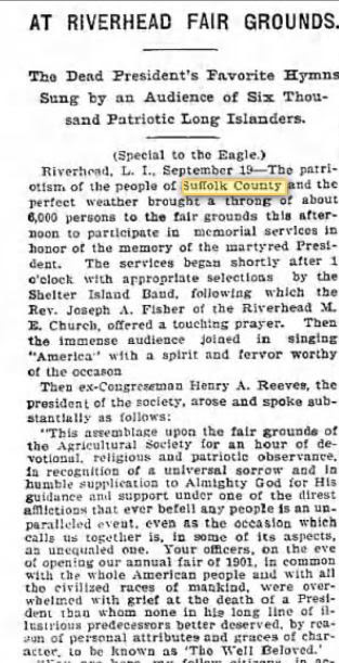
MEMORIAL SERVICE FOR PRESIDENT McKINLEY (Brooklyn Eagle, 1901)
As reported in the Brooklyn Eagle on September 19, 1901, over six thousand people from Suffolk County were in attendance at the Riverhead Fair Grounds for a memorial service for President McKinley, who had been assassinated four days earlier. “The services began shortly after 1 o’clock with appropriate selections by the Shelter Island Band” and a touching prayer by Rev. Joseph Fisher of the Riverhead M.E. Church. The “immense audience joined in singing ‘America’ with a spirit and fervor worthy of the occasion.”
——————————————————
SCHS Photo of the Week: Click Here to Visit Webpage.
Visit: www.suffolkcountyhistoricalsociety.org
To view 2014 Photo of the Week pages click here.
_________________________________________________________
PHOTO OF THE WEEK: July 10, 2015 — FROM THE SCHS LIBRARY ARCHIVES
“How shall we know it is us without our past?” – John Steinbeck
LILCO Advertisement: “Magical Energy Sources,” 1970
by Wendy Polhemus-Annibell, Librarian
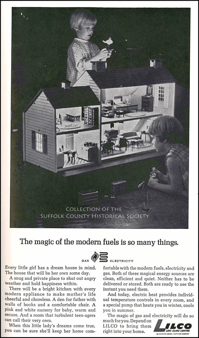
Image copyright Suffolk County Historical Society
1970 LILCO Advertisement: “The magic of the modern fuels is so many things.” (Image from the Collection of the Suffolk County Historical Society Library Archives.)
This 1970 LILCO ad reads as follows:
Every little girl has a dream house in mind. The house that will be her own some day.
A snug and private place to shut out angry weather and hold happiness within.
There will be a bright kitchen with every modern appliance to make mother’s life cheerful and choreless. A den for father with walls of books and a comfortable chair. A pink and white nursery for baby, warm and secure. And a room that turbulent teen-agers can call their very own.
When this little lady’s dreames come true, you can be sure she’ll keep her home comfortable with the modern fuels, electricity and gas. Both of these magical energy sources are clean, efficient, and quiet. Neither has to be delivered or stored. Both are ready to use the instant you need them.
And today, electric heat provides the individual temperature controls in every room, and a special pump that heats you in winter, cools you in summer.
The magic of gas and electricity will do so much for you. Depend on LILCO to bring them right into your home.
_________________________
NEW & NOTEWORTHY!
Access to portions of Ancestry.com pertaining to New York is now FREE to New York State residents. The New York State Archives has partnered with Ancestry.com to digitize some New York State records of interest to genealogists and others interested in tracing their family history. The resulting online databases are free to access if you live in New York State:
http://www.archives.nysed.gov/research/res_ancestry.shtml
Once you enter your Zip code, you’ll be asked to register for a free account.
——————————————————
SCHS Photo of the Week: Click Here to Visit Webpage.
Visit: www.suffolkcountyhistoricalsociety.org
To view 2014 Photo of the Week pages click here.
_________________________________________________________
PHOTO OF THE WEEK: July 3, 2015 — FROM THE SCHS LIBRARY ARCHIVES
“How shall we know it is us without our past?” – John Steinbeck
Torpedo Boat Destroyer, Shelter Island, 1903
by Wendy Polhemus-Annibell, Librarian
[To view Hal B. Fullerton photograph visit webpage link below.]
Torpedo Boat Destroyer, Shelter Island, August 1903, by Hal B. Fullerton. (Image from the Harry T. Tuthill Fullerton Collection of the Suffolk County Historical Society Library Archives [149.7.959]. Copyright © Suffolk County Historical Society. All rights reserved.)
A torpedo boat is a relatively small but fast naval ship designed to carry torpedoes into battle. The first designs rammed enemy ships with explosive spar torpedoes, whereas later designs launched self-propelled Whitehead torpedoes. They were created to counter battleships and other large, slow, and heavily armed ships by speed and agility. A large number of torpedo boats attacking simultaneously could overwhelm a larger ship’s ability to fight them off using its slower-firing guns. A fleet of torpedo boats could thereby defend against much larger fleets.
The introduction of fast torpedo boats in the late nineteenth century was a serious concern to navies of the era. In response, navies operating large ships introduced smaller ships to counter the threat. Initially, these were somewhat larger than the torpedo boats they faced, and mounted a light gun battery as well as torpedoes. As these designs became more formalized, they became known as torpedo boat destroyers–and these, in turn, evolved into the modern destroyer. Today the class is generally known as fast-attack craft.
——————————————
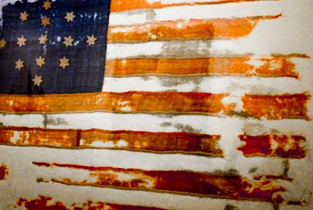 The Hulbert Flag, c. 1775.
A controversial artifact from the SCHS permanent collection believed by some to have been made by Captain John Hulbert of Bridgehampton and carried by him and his militiamen from Fort Ticonderoga to Philadelphia in 1775 where, after having been seen by representatives at the Continental Congress, it might have influenced the design of the first American flag. The flag has been examined by a number of experts who remain divided over the oral tradition of the flag’s origins. The Hulbert Flag remains one of the best known and most discussed artifacts in our museum’s collections.
——————————————————
SCHS Photo of the Week: Click Here to Visit Webpage.
Visit: www.suffolkcountyhistoricalsociety.org
To view 2014 Photo of the Week pages click here.
_________________________________________________________
PHOTO OF THE WEEK: June 26, 2015—FROM THE SCHS LIBRARY ARCHIVES
“How shall we know it is us without our past?” – John Steinbeck
Lake Ronkonkoma, 1917
by Wendy Polhemus-Annibell, Librarian
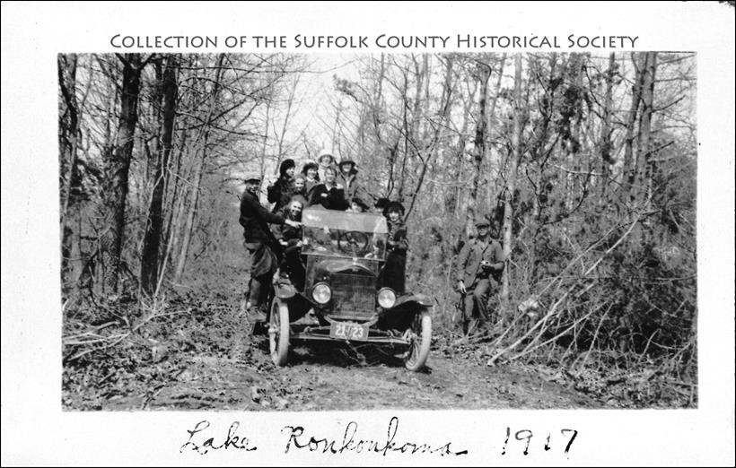 Lake Ronkonkoma, 1917. Unidentified members of the Clock and Huntoon families of Sayville on an outing to Lake Ronkonkoma. (Image from the Clock Collection of the Suffolk County Historical Society Library Archives. Copyright © Suffolk County Historical Society. All rights reserved.)
Lake Ronkonkoma was once a resort town, until the area experienced a population explosion in the mid-twentieth century. Remnants of old resorts and hotels can still be found around the lake’s shores, and many summer cottages and bungalows from that period remain, now converted to year-round residential use.
The area’s lake is the largest lake on Long Island. Because it is a groundwater lake–one not fed by streams and with no outlet–its water surface reflects the current level of the local water table. The lake is relatively deep (about 65 feet) and is a kettle hole lake.
The lake is also the subject of a number of urban legends, mainly rooted in the area’s rich Native American heritage, including the legend of Princess Ronkonkoma, the lady of the lake who supposedly drowned in the lake herself and calls young men out to the middle of the lake to drown them. Not an urban legend is the fact that Lake Ronkonkoma was considered a sacred lake by Native Americans.
Suggested Readings
Fall of Apple Blossom Time: A Memoir of Lake Ronkonkoma, by Lawrence M. Holzapfel (2001).
Historical Footprints at Lake Ronkonkoma, by Lois J. Watt (1963).
Three Waves: The Story of Lake Ronkonkoma, by Ann Farnum Curtis (1976).
——————————————————
SCHS Photo of the Week: Click Here to Visit Webpage.
Visit: www.suffolkcountyhistoricalsociety.org
To view 2014 Photo of the Week pages click here.
_________________________________________________________
PHOTO OF THE WEEK: June 19, 2015 — FROM THE SCHS LIBRARY ARCHIVES
“How shall we know it is us without our past?” – John Steinbeck
The Louis Philippe “Shipwreck Rose,” East Hampton, 1842
by Wendy Polhemus-Annibell, Librarian
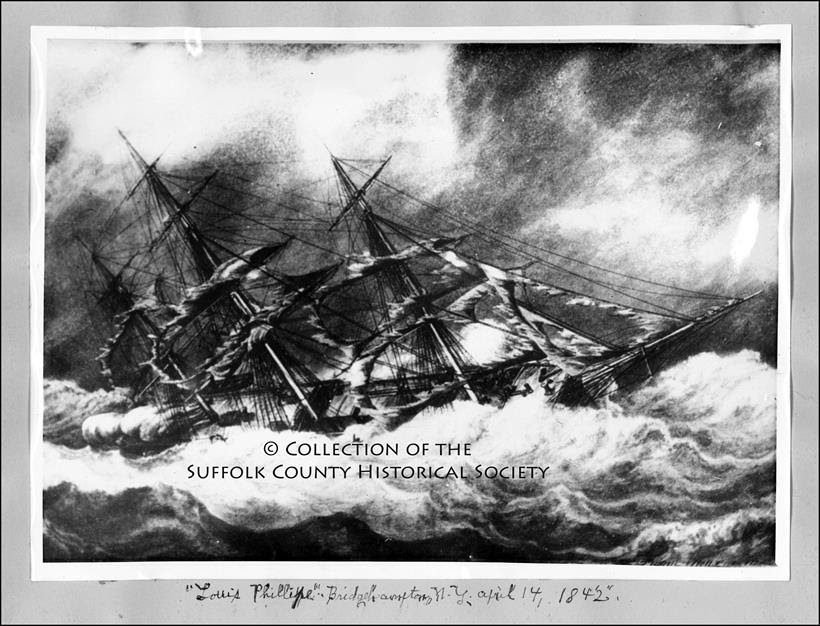 The Louis Philippe “Shipwreck Rose,” East Hampton, 1842. Louis Philippe, Bridgehampton, April 14, 1842, painting by François Joseph Frédéric Roux, Havre, 1843. (Image from the H.B. Squires Shipwrecks Collection of the Suffolk County Historical Society Library Archives. Copyright © Suffolk County Historical Society. All rights reserved.)
On April 14, 1842, the rigged packet ship Louis Philippe, on its way from Bordeaux, France, to New York City, was grounded at Mecox Beach in Bridgehampton. The ship’s deck cargo of linden trees, shrubs, and rosebushes was thrown overboard to lighten the load so that the salvage tugs could free the ship by hauling it into deeper water. All of the passengers were saved and the ship itself was eventually salvaged.
As the cargo washed up on shore that day, local East Hampton Town residents on the beach at the time gathered the horiticultural specimens from France and planted many of the trees, shrubs, and rosebushes throughout the town. Some of the elm trees that stood along Main Street in East Hampton until the 1938 hurricane blew them down were reportedly from the Louis Philippe shipwreck.

R
Probably the most wonderful and long-lasting gift the Louis Philippe brought to East Hampton in 1842 is an old garden rose known locally as the “Shipwreck Rose” (or “East Hampton Rose” or “Louis Philippe Rose”), which continues to thrive in East Hampton gardens today. A very fragrant and winter hardy, once-blooming light pink rose with lovely yellow stamens, the original specimen of the Shipwreck Rose has been passed down by cuttings or transplants for many generations of East Hampton gardeners. Today we know the Shipwreck Rose is actually a Dutch damask rose named ‘Celsiana’, bred in the Netherlands in the early 1700s and introduced in France in c. 1812; it was named after Jacque-Martin Cels, a French nursery grower.
If you happen to see ‘Celsiana’ in bloom in East Hampton or elsewhere, do take the time to stop, savor its beauty, and smell its intoxicating damask fragrance.

A bowl of assorted old garden roses from my garden. Image courtesy Wendy Polhemus-Annibell.
‘Celsiana’ Facts: Light pink, golden-yellow stamens, ages to white. Strong, damask fragrance. Average diameter 2.75″. Semi-double (9-16 petals), cluster-flowered, in small clusters bloom form. Once-blooming spring or summer. Upright. Height of 3′ to 6′. Width of 3′ to 5′. Hardy in USDA zones 4b to 9b. Vigorous. Spreads by runners/suckers.
——————-
Suggested Readings
Awakening the Past: The East Hampton 350th Anniversary Lecture Series, edited by Tom Twomey (Newmarket Press, 1998).
Classic Roses, by Peter Beales (Random House, 2002).
Old Garden Roses & Beyond, by Paul Barden (http://www.paulbardenroses.com/main.html).
——————————————————
SCHS Photo of the Week: Click Here to Visit Webpage.
Visit: www.suffolkcountyhistoricalsociety.org
To view 2014 Photo of the Week pages click here.
_________________________________________________________
PHOTO OF THE WEEK: June 12, 2015 — FROM THE SCHS LIBRARY ARCHIVES
“How shall we know it is us without our past?” – John Steinbeck
Montgomery Ward Grand Opening, Riverhead, 1964
by Wendy Polhemus-Annibell, Librarian
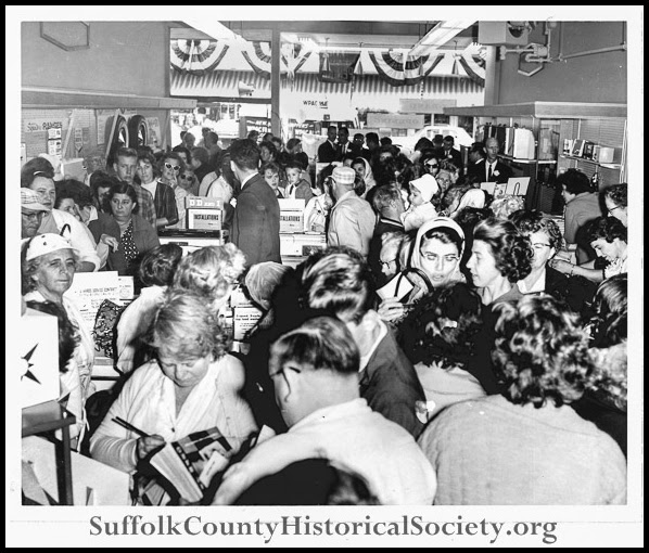
Grand Opening of the Montgomery Ward Catalog Store, Riverhead, 1964. (Image from the Sigal Collection of the Suffolk County Historical Society Library Archives [172.33.1G]. Copyright © Suffolk County Historical Society. All rights reserved.)
In 1872, Aaron Montgomery Ward, a traveling dry goods salesman, started selling to farmers by mail order via a one-page catalog list. By inventing the mail-order catalog, Ward could keep prices low through bypassing the small-town shopkeepers and itinerant salesmen. In 1875, Ward pioneered another practice now taken for granted: “Satisfaction Guaranteed or Your Money Back!”
Montgomery Ward’s Catalog Store opened in 1964 in Riverhead at 127 East Main Street to a huge crowd of local shoppers. The two-story Sigal Building was built in 1938 by Al Sigal, a Riverhead developer who kept his offices on the second floor. None of the original façade, which was sheathed in green and black carrara glass panels separated by chrome strips, remains intact. On the east side there was a drive through to a back parking area. The entrance hall was lined with red marble from the French luxury liner Normandie, which burned in New York Harbor in 1942. The building once housed “House of Music” and then Montgomery Ward and other stores. Today the building is home to Vines & Hops.
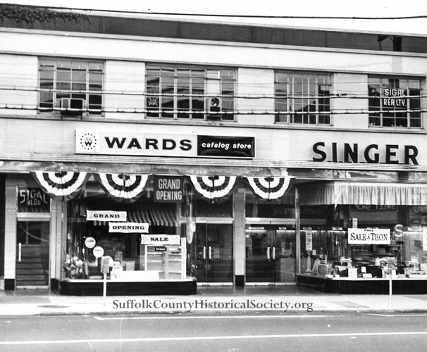
Image from the Sigal Collection of the Suffolk County Historical Society Library Archives [172.33.1G]. Copyright © Suffolk County Historical Society. All rights reserved.
——————————————————
SCHS Photo of the Week: Click Here to Visit Webpage.
Visit: www.suffolkcountyhistoricalsociety.org
To view 2014 Photo of the Week pages click here.
_________________________________________________________
PHOTO OF THE WEEK: June 5, 2015 — FROM THE SCHS LIBRARY ARCHIVES
“How shall we know it is us without our past?” – John Steinbeck
Nazis Land in Amagansett, June 1942
by Wendy Polhemus-Annibell, Librarian
 Nazi Sabateur George J. Dasch, c. 1940s. (Image from the Vagts Collection of the Suffolk County Historical Society Library Archives [183.187.31]. Copyright © Suffolk County Historical Society. All rights reserved.)
George J. Dasch (1903-1992) was one of four specially trained Nazi saboteurs who landed from the German submarine U-202 at Amagansett in June 1942. The sabateurs’ mission was to destroy aluminum smelting plants so local aircraft production plants could not obtain a supply of the strong, lightweight metal.
On May 26, 1942, Dasch and his team (Ernest P. Burger, Heinrich H. Heink, and Richard Quirin) left by submarine from Lorient, France, and landed at Amagansett shortly after midnight on June 12. They were wearing German Navy uniforms to avoid being shot as spies if captured during the landing. Once ashore, they changed to civilian clothing and buried their uniforms and other equipment in the sand. Early that morning, John C. Cullen, a Coast Guardsman from the Amagansett station, spotted Dasch and the three others posing as fishermen. He saw that the men were armed and also noticed a submerged submarine. The men offered Cullen a $250 bribe to keep quiet–and while he did accept their bribe, he also alerted his superiors. By the time an armed patrol returned to the site, however, the Nazis had boarded a LIRR train from Amagansett to New York City, where they checked in at a hotel. A search of the Amagansett beach revealed concealed explosives, timers, blasting caps, incendiary devices, cigarettes, and the Nazi uniforms. When it was realized that Nazi agents had landed at eastern Long Island and were on American soil, President Franklin D. Roosevelt and FBI Director J. Edgar Hoover were alerted, and the FBI conducted a massive manhunt.
Dasch was one of two saboteurs who were not executed. He betrayed the Nazi plot and thereby enabled the FBI to capture the Nazi saboteurs who had landed at Long Island and the Florida coast. He was tried and convicted of treason and espionage.
SUGGESTED READING: “George John Dasch and the Nazi Saboteurs,” Famous Cases and Criminals, by the Federal Bureau of Investigation. http://www.fbi.gov/about-us/history/famous-cases/nazi-saboteurs
——————————————————
SCHS Photo of the Week: Click Here to Visit Webpage.
Visit: www.suffolkcountyhistoricalsociety.org
To view 2014 Photo of the Week pages click here.
_________________________________________________________
PHOTO OF THE WEEK: May 29, 2015 — FROM THE SCHS LIBRARY ARCHIVES
“How shall we know it is us without our past?” – John Steinbeck
Fire Island Life Saving Station, 1908
by Wendy Polhemus-Annibell, Librarian
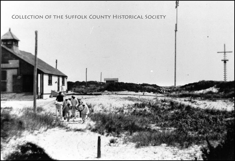
Fire Island Life Saving Station, 1908. A life-saving crew begins a drill at the station on August 31, 1908. (Image from the Vagts Collection of the Suffolk County Historical Society Library Archives [183.187.5]. Copyright © Suffolk County Historical Society. All rights reserved.)
“The sea worked on the piles of rubble and as the glaciers melted and ran off to the south they formed Long Island, with rocks on the North Shore and sand on the South Shore. This all adds up to that ‘littoral drift’ along the South Shore, forming what we now know as Fire Island.”
– Paul Stoutenburgh, Old Inlet: Fire Island
The first life-saving station on Fire Island was built in 1848, at the western end of the island, adjacent to the site of the first Fire Island Lighthouse. The second life-saving station was built at Moriches Inlet. By 1854, there were seven stations located at Fire Island, Point O’ Woods, Lone Hill, Blue Point, Bellport, Smith’s Point and Forge River.
These early life-saving stations were run entirely by volunteers. Local baymen and farmers lived at the stations from October until May to patrol the coastline for stranded ships and perform rescues when needed. Known as Surfmen, the volunteers’ motto was “You must go out, but you don’t have to come back.” They patrolled the beach on foot every night, from sunset until sunrise, looking for shipwrecks. When a stranded ship was sighted, the volunteer crew performed a rescue using a buoy with lines and pulleys. A small cannon was used to shoot a projectile, or weight, carrying a light line out to the ship. Although very simple, this method was used to rescue over 7,000 people from more than 700 ships off Fire Island from 1871 to 1915, when the newly created U.S. Coast Guard took control of the stations.
In 1871, Congress appropriated money for paid crews at all life-saving stations, and in 1874, the Life Saving Stations Act required boat captains to report all shipwrecks.
SUGGESTED READINGS: Fire Island: 1650s-1980s, by Madeleine C. Johnson (Shoreland Press, 1983); Discovering Fire Island, by Bill Perry (National Park Service, 1978); Old Inlet: Fire Island, by Paul Stoutenburg (Author, 1979).
——————————————————
SCHS Photo of the Week: Click Here to Visit Webpage.
Visit: www.suffolkcountyhistoricalsociety.org
To view 2014 Photo of the Week pages click here.
_________________________________________________________
PHOTO OF THE WEEK: May 22, 2015 — FROM THE SCHS LIBRARY ARCHIVES
“How shall we know it is us without our past?” – John Steinbeck
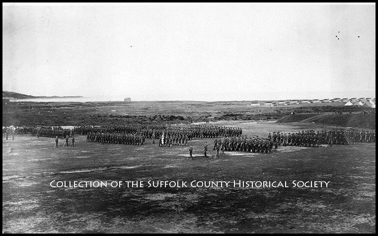
Fishers Island Coastal Fort: World War I Era
by Wendy Polhemus-Annibell, Librarian
Fishers Island Coastal Fort: World War I Era, 13th Regiment of Brooklyn. (Image from the Gibson Collection of the Suffolk County Historical Society [195.52.28]. Copyright © Suffolk County Historical Society. All rights reserved.)
Fort H. G. Wright, begun in 1898, was a U.S. military installation on Fishers Island that was active during the first and second world wars. Named for Union General Horatio G. Wright (1820-1899), the coastal fort guarded the passage into Long Island Sound from the Connecticut shoreline to Great Gull Island, It was linked with Fort Terry, Fort Michie, and Camp Hero. By World War II, the fort had a small airfield. It was decommissioned in 1948.
The Brooklyn Daily Eagle reported in 1926 that Brooklyn’s 13th Regiment held “one of the most picturesque and impressive review ceremonies in the history of the famous command at Fort H. G. Wright. Generals Charles P. Summerall and Georges A. L. Dumont took the salute of the marching Brooklyn guardsmen. The review of the regiment by the generals culminated a week of formal military pageantry.”
On Memorial Day, we commemorate our brave soldiers who sacrificed their lives for our freedom.
SUGGESTED READING: The Coastal Forts of Eastern Long Island, by Ruth Ann Bramson, Geoffrey K. Fleming, & Amy K. Folk.
——————————————————
SCHS Photo of the Week: Click Here to Visit Webpage.
Visit: www.suffolkcountyhistoricalsociety.org
To view 2014 Photo of the Week pages click here.
_________________________________________________________
PHOTO OF THE WEEK: May 15, 2015 — FROM THE SCHS LIBRARY ARCHIVES
“How shall we know it is us without our past?” – John Steinbeck
Kings Park State Hospital, 1925
by Wendy Polhemus-Annibell, Librarian
Kings Park State Hospital, 1925. (Image from the Smithtown Pictorial Collection of the Suffolk County Historical Society [176.29.2]. Copyright © Suffolk County Historical Society. All rights reserved.) This photograph by P. Hildenbrand was taken from the top of the power plant’s smokestack, at “215 feet high,” according to the photographer’s notes. In the background are the Nissequogue River and Short Beach.
The Kings Park “Lunatic Asylum” was established in 1885 on 800 acres. The state took over control of the facility in 1895, and the name was changed to Kings Park State Hospital. A self-sufficient farm community was established, providing work for staff members and nurses. In addition, about 70 percent of patients worked various jobs on the hospital grounds. In 1900, the hospital housed nearly 3,000 patients and almost 500 staff members, giving the hospital a larger population than the Town of Smithtown. There were over 150 permanent buildings, including a laundry, bakery, library, nursing school, recreation hall, bandstand, and many repair and construction shops. Kings Park constructed its own railroad spurs in order to bring in coal and supplies from the LIRR line. The LIRR also had a Sunday-only passenger train to and from the grounds of the hospital for visitors. Kings Park State Hospital closed in 1996. Its mentally ill population peaked in the late 1950s with over 9,000 patients.
——————————————————
SCHS Photo of the Week: Click Here to Visit Webpage.
Visit: www.suffolkcountyhistoricalsociety.org
To view 2014 Photo of the Week pages click here.
_______________________________________________________
PHOTO OF THE WEEK: May 8, 2015 — FROM THE SCHS LIBRARY ARCHIVES
“How shall we know it is us without our past?” – John Steinbeck
Prosperity Farm, Medford, c. 1910
by Wendy Polhemus-Annibell, Librarian
Photograph — to view Hal B. Fullerton photograph please visit the Suffolk County Historical Society’s website.
Photo caption: Eleanor Fullerton by Rambling Roses on Arbors at Prosperity Farm, Medford, c. 1910, by Hal B. Fullerton. (Image from the Harry T. Tuthill Fullerton Collection of the Suffolk County Historical Society [autochrome glass plate, 193.4.7]. Copyright © Suffolk County Historical Society. All rights reserved.)
“One thing I am sure of,” Edith Fullerton wrote in Small Gardens for Small Folks, “if you make a garden and become better acquainted with Mother Nature, you will live much more happily than before. Mother Nature, next to your own mother, is the very best friend you have.”
In 1907, on 80 acres in Medford, the Long Island Rail Road’s Agricultural Department established Prosperity Farm (officially called Experimental Station #2) following Hal and Edith Fullerton’s huge success at the much smaller Experimental Farm #1, Peace & Plenty, in Wading River. Two portable buildings (one of them with five rooms) were installed for the Fullertons, who left their home in Huntington to live on the Medford farm. Prosperity also became the new headquarters for the Fullertons’ Agronomist, a popular horticultural periodical publication. Before long the family was referring to the new farm as the “Homestead.”
Daughter Eleanor Fullerton, pictured here among rambling roses in bloom, writes in My Long Island (1993): “When Dad had proved that the North Shore could blossom like a rose, the cry went up that he had good soil there [in Wading River] but that the middle of the Island–that land of pitch pine, scrub oak, and sandy soil [in Medford]–was useless. To Dad, however, there was not an inch of the Blessed Isle that wasn’t pure gold, so he pursuaded the LIRR…to sanction a second farm.”
Espousing progressive farming and gardening techniques, the Fullertons dispensed useful advice and taught by practical example. In 1910 the opening of a direct rail route between Medford and the newly completed Pennyslvania Station brought attention to the farm as the Fullertons immersed themselves in farm activities and expanded their promotional efforts through lectures, exhibitions, and publications. The farm’s specialties included small fruits, such as raspberries, gooseberries, currants, grapes, strawberries, apples, and plums. Eventually, Prosperity Farm grew to include a thousand varieties of plants as well as a dairy farm.
As a family with three growing children–Eleanor, Hope, and Loring–the Fullertons were concerned about improving the Medford community. Largely through their efforts, a new schoolhouse, polling place, Grange Hall, and library were added to the village in 1910 to 1917. With her training in early childhood education, Edith Fullerton involved her own and others’ children in farm activities. Young Folks Clubs (one each for corn, potatoes, and cauliflower) were established by the Fullertons to offer young adults annual cash prizes for crop reports on their cultivation of produce.
Edith Fullerton published widely, including The Lure of the Land, How to Make a Vegetable Garden, Small Gardens for Small Folks (W. Atlee Burpee Seed Co., 1912), “The Child’s Garden” (in Country Gentleman magazine), and The Book of the Home Garden, among others.
The Fullertons presided over the experimental station in Medford until 1914, when expansion of the LIRR Agriculture Dept. ended.
Photograph — to view please visit the Suffolk County Historical Society’s website.
Caption: Edith Loring Fullerton with her daughters Eleanor and Hope, c. 1905. (Image from the Harry T. Tuthill Fullerton Collection of the Suffolk County Historical Society [191.53.16]. Copyright © Suffolk County Historical Society. All rights reserved.)
——————————————————
SCHS Photo of the Week: Click Here to Visit Webpage.
Visit: www.suffolkcountyhistoricalsociety.org
To view 2014 Photo of the Week pages click here.
_________________________________________________________
PHOTO OF THE WEEK: May 1, 2015 — FROM THE SCHS LIBRARY ARCHIVES
“How shall we know it is us without our past?” – John Steinbeck
The 1858 Chace Map of Suffolk County
by Wendy Polhemus-Annibell, Librarian
Portion of the Chace Map of Suffolk County, Long Island, New York, 1858. (From the Collection of the Suffolk County Historical Society.)
The 1858 Chace Map hanging on a wall in our Library Archives is one of the finest maps of Suffolk County ever made, as well as one of our most popular resources with library patrons. The surveys for the map were the work of J. Chace Jr., and the map was published by Robert Pearsall Smith (the cartographer) and John Douglass in 1858.
This monumental map covers Long Island from Huntington to Montauk and Orient Point. Divided into two main sections, upper and lower, the upper section focuses on Huntington, Smithtown, Islip, and Brookhaven (including most of Fire Island and Oak Island). The lower section covers the eastern end of Long Island, including Brookhaven, Riverhead, Southampton, Southold, East Hampton, Gardiner’s Island, and Shelter Island. The map also includes detailed sections for parts of Amityville, East Setauket, Commack, West Huntington, and many other areas.
The extraordinary detail throughout the entire map is especially noteworthy, with Chace’s survey work being the most accurate and in-depth study of the region undertaken in the first half of the nineteenth century. Chace specified roads, farms, bridges, and the individual family names of various properties. In addition to noting property owners and important households, the map includes business directories for the largest and most important towns, as well as engraved views of the Riverhead Courthouse and of prominent homes in Greenport, Good Ground, and Aquebogue.
Come take a look! The1858 Chace Map is available for viewing during Library hours: Wednesday – Saturday, 12:30 – 4:30 PM.
—————————————————————-
SCHS Photo of the Week: Click Here to Visit Webpage.
Visit: www.suffolkcountyhistoricalsociety.org
To view 2014 Photo of the Week pages click here.
_________________________________________________________
PHOTO OF THE WEEK: April 24, 2015 — FROM THE SCHS LIBRARY ARCHIVES
“How shall we know it is us without our past?” – John Steinbeck
An Oldsmobile in Amityville, 1908
by Wendy Polhemus-Annibell, Librarian
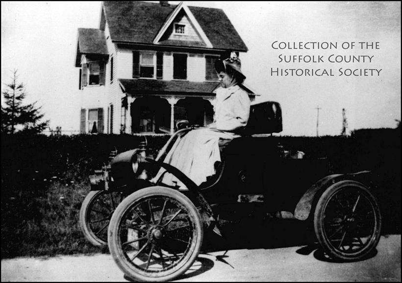 Carrie De Le Ree in Curved Dash Oldsmobile, Richmond Ave., Amityville, 1908. Image from the Babylon Town Pictorical Collection of the Suffolk County Historical Society. Copyright © Suffolk County Historical Society. All rights reserved.
The area we know today as Amityville had originally been called West Neck South or Huntington South. President George Washington referred to his visit to “Huntington South” in 1790, when during his post-revolutionary trip across Long Island he had occasion to dine at the East Amityville home of Zebulon Ketcham. As the community continued to be slowly settled, the people began to feel the need for a more distinct geographical name. The name Amityville probably came into use sometime between 1840 and 1850. Some say that during one of the meetings to choose a name for the community, a difference of opinion erupted and then escalated into a near brawl over the choice of the name “Contraryville.” At one point a doctor said he would not live in a place called “Contraryville,” and that the choice of name should be a friendly one. Then he or someone else said fine, let’s call the place “Amity” for friendship, which evolved into “Amityville.”
Sufficiently established by the mid-nineteenth century, the community of Amityville now had a post office and, by 1867, a railroad station. Like other South Shore communities in the early twentieth century, Amityville developed into a summer playground, where the rich and famous built homes, rented cottages, or relaxed in seaside hotels. Even Al Capone came to reside in Amityville to set up his bootlegging operation.
Suggested Reading: A Brief History of Amityville, Long Island, N.Y., 2nd ed., by William T. Lauder (Amityville Historical Society, 1973).
—————————————————————-
SCHS Photo of the Week: Click Here to Visit Webpage.
Visit: www.suffolkcountyhistoricalsociety.org
To view 2014 Photo of the Week pages click here.
_________________________________________________________
PHOTO OF THE WEEK: April 17, 2015 — FROM THE SCHS LIBRARY ARCHIVES
“How shall we know it is us without our past?” – John Steinbeck
Gil Smith, Master Boatbuilder, 1843-1940
by Wendy Polhemus-Annibell, Librarian
 “Moonbeam” (Sail #4, reproduction). The Moonbeam, a racing champion created in 1909, was the most versatile small boat of all Gil Smith’s celebrated designs. Image from the Gil Smith Pictorial Collection of the Suffolk County Historical Society. Copyright © Suffolk County Historical Society. All rights reserved.
Gilbert Monroe Smith (1843-1940), a lifelong Long Islander, was a master boatbuilder best known for building very fine, very fast sailboats that were difficult to beat in a race. A 1963 New York Times article described Gil Smith’s catboats, highly prized racing craft on Long Island, as “examples of master craftsmanship and pioneering design that is acknowledged by the Smithsonian Institution.”
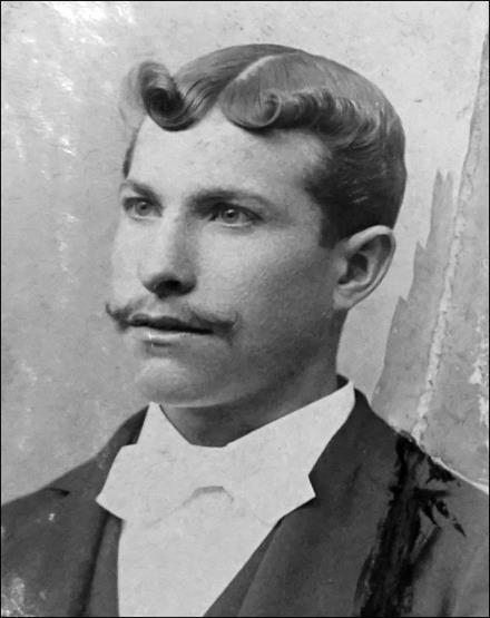
Born in Manorville in 1843, Gil Smith built his first sailboat at age seventeen. He was a sailor on coastal schooners and, during the Civil War, a seaman aboard vessels that brought supplies to Union soldiers. He also worked as a bayman and duck hunter, and crafted duck decoys and gunning boats. Interestingly, both Smith and his wife were descendants of families that landed in Southold in 1640 (the Hallocks and the Terrys, respectively).
After moving with his wife and five children to Amity Street in Patchogue in 1876, Gil Smith set up shop on the Patchogue River, where he established himself as a master boatbuilder, crafting sailboats for local baymen and for highly competitive sportsmen to race on the Great South Bay. His method involved making a perfectly crafted half model first, and then with meticulous care he would build an exact enlargement of the half model. (A series of Gil Smith’s original half models were donated by his family to the permanent collection of the Suffolk County Historical Society.) Smith built an estimated four hundred boats at Patchogue for over sixty years before his death in 1940 at the age of ninety-seven.
On Saturday, April 18, the Suffolk County Historical Society will celebrate Long Island’s maritime history with the opening of a new exhibition, From Shore to Shore: Boatbuilders and Boatyards of Long Island. The exhibit will also feature many rarely seen maritime photographs by Hal B. Fullerton from our collection, as well as a magnificent maritime painting exhibit curated by J. Russell Jinishian and Fred Polhemus. An opening reception will commence at 5:00 PM. Admission is free. Visit our website for details.
—————————————————————-
SCHS Photo of the Week: Click Here to Visit Webpage.
Visit: www.suffolkcountyhistoricalsociety.org
To view 2014 Photo of the Week pages click here.
_________________________________________________________
PHOTO OF THE WEEK: April 10, 2015 — FROM THE SCHS LIBRARY ARCHIVES
“How shall we know it is us without our past?” – John Steinbeck
Firemen’s Tournament Parade, Sayville, 1899
by Wendy Polhemus-Annibell, Librarian
Firemen’s Tournament Parade, Sayville, 1899, by Hal B. Fullerton. Image from the Harry T. Tuthill Fullerton Collection of the Suffolk County Historical Society. Copyright © Suffolk County Historical Society. All rights reserved. To view photo by Hal B. Fullerton, please visit www.suffolkcountyhistoricalsociety.org
In 1836, fifty years after its initial settlement in circa 1786, Sayville finally got a name. Tired of being called “Over South,” the area’s residents met in the old Bedell Tavern on Main Street to choose a name for the community. The result was a tie among Edwardsville, Greenville, and Judea, which referred to community founders, but then someone suggested Seaville or Seville. This name was adopted but, some local histories assert, the clerk misspelled it as “Sayville.”
Over time, Sayville has been a major source of wood for New York City, with an abundant pine forest north of the village; one of the oyster capitals of the United States; a center of Long Island theater arts with the Sayville Opera House; and a bustling resort town after the LIRR arrived in 1868. Ten years later, in 1878, when the charter of the Sayville Hook and Ladder Company was signed on top of a grand piano in Columbia Hall, it became the first incorporated company in all of Suffolk County. Today in West Sayville, our island’s maritime history is preserved by the Long Island Maritime Museum.
On April 18, the Suffolk County Historical Society will celebrate Long Island’s maritime history with the opening of a new exhibition: From Shore to Shore: Boatbuilders and Boatyards of Long Island. An opening reception will commence at 5:00 PM. Admission is free. Visit our website for details.
Recommended Reading: For more on the history of Sayville, see A History of Early Sayville, by Clarissa Edwards (1935), and East on the Great South Bay: Sayville and Bayport, by Harry W. Havemeyer (2001), in our library collection.
—————————————————————-
SCHS Photo of the Week: Click Here to Visit Webpage.
Visit: www.suffolkcountyhistoricalsociety.org
To view 2014 Photo of the Week pages click here.
_________________________________________________________
PHOTO OF THE WEEK: April 3, 2015 — FROM THE SCHS LIBRARY ARCHIVES
“How shall we know it is us without our past?” – John Steinbeck
The Old Red Mill in Springtime, Riverhead
by Wendy Polhemus-Annibell, Librarian
The Old Red Mill in Springtime, Riverhead. Image from the SCHS Carleton Kelsey Postcard Collection; copyright © Suffolk County Historical Society. All rights reserved.
The Little Red Mill is generally credited by historians as being the first saw mill ever erected on Long Island. Some time before about 1659, when Riverhead was part of Southold, John Tucker received permission from the Southold Town authorities to set up the mill. According to the Southold Town Records:
“At a meetinge of the Towne John Tucker propounded for liberty to sett upp a saw mill inplace most convenient within the Towne bounds neer the head of the River [Riverhead] and liberty to cutt all sorts of timber…. The [permission for Tucker to build the saw mill] was granted…uppon his promise [that] the Towne of Southold should be first from tyme to tyme supplyed with boards for every mans particular use…” (Vol. 1, p. 102).
For 250 years the Peconic River provided power for milling operations. The first, the Little Red Mill or Tucker’s saw mill, was followed by grist mills, more saw mills, planing and moulding mills, a paper mill, a woolen mill, a fulling mill (where the newly woven wool was scoured), a flour mill, a sorghum mill, and eventually an electric power plant. Riverhead once had a hamlet named Upper Mills, which tooks its name from the several mills located on the upper part of the Peconic River.
On Friday, March 11, 1938, the Riverhead News declared “Little Red Mill, Old Landmark Is Disappearing–Quaint Structure Believed to Be First ‘Business’ Building in Riverhead.” The mill on Peconic Avenue was demolished by its owner, Frank Woodhull, to permit the extension of a newer building, the Riverhead Auto Parts.
INFO. SOURCES: “A Brief History of Early Riverhead Town,” by Justine W. Wells (1992); “Peconic River Mills and Industries,” by Edna Howell Yeager (1965).
—————————————————————-
SCHS Photo of the Week: Click Here to Visit Webpage.
Visit: www.suffolkcountyhistoricalsociety.org
To view 2014 Photo of the Week pages click here.
_________________________________________________________
PHOTO OF THE WEEK: March 27, 2015 — FROM THE SCHS LIBRARY ARCHIVES
March Is Women’s History Month!
A Portrait of Long Island’s Suffragists, 1913
by Wendy Polhemus-Annibell, Librarian
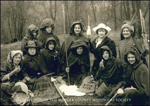
Long Island’s Suffragists: March to Washington, DC, February 1913. Image from the SCHS Pictorial Collection; copyright © Suffolk County Historical Society. All rights reserved.
Today’s Photo of the Week features a group of courageous Long Island suffragists during their two-week, 250-mile hike from New York to Washington, DC, in February 1913. In the center is Rosalie Gardiner Jones of Cold Spring Harbor (bottom row, fourth from left), the energetic president of the Nassau County branch of the National American Woman Suffrage Association.
Ms. Jones became a prominent and tireless spirit in the suffrage struggle and was dubbed “General Rosalie” owing to her leadership in the famous suffrage hikes from New York to Albany and from New York to Washington, DC, during the Wilson administration. During the latter hike pictured here, the women wore brown pilgrim capes with hoods; they arrived in DC in March 1913 to participate in the famous suffrage parade in the U.S. Capitol (click here to see a related image from the Library of Congress).
It was during a presidential election year that women first obtained the right to vote. The Nineteenth Amendment went through in 1920, but it was a long uphill battle, and Rosalie and many others were in the thick of it. The outspoken heiress posted huge signs on her Cold Spring Harbor estate urging “Votes for Women,” picketed the White House, and paraded through Washington streets with fellow suffrage activists, carrying banners and flags. They even got in to see President Woodrow Wilson! “I’m sure everyone thought we were crazy,” Rosalie recalled. “I imagine we looked more like circus performers than women seeking President Wilson’s aid. He was very nice but a bit conservative.”
Other Long Island Suffrage Activists
Harriet Stanton Blatch brought radical suffrage tactics from England and held suffrage events at her home in Shoreham. Harriet Burton Laidlaw held offices in national and state suffrage organizations and hosted events at her Sands Point home. Edna Kearns of Rockville Centre edited suffrage articles for the Brooklyn Daily Eagle and toured Long Island with General Rosalie and Elizabeth Freeman on the “Spirit of 1776” suffrage wagon. Gertrude Foster Brown of Bellport was vice-president of the National American Woman Suffrage Association and chaired a state committee that hosted a suffrage exhibit at the Mineola Fair.
On August 26, 1920, the U.S. Secretary of State certified the Nineteenth Amendment as part of the U.S. Constitution:
“The right of citizens of the United States to vote shall not be denied or abridged by the United States or by any State on account of sex.”
INFO. SOURCES: “The American Standard of Living and World Co-operation,” by Rosalie Jones (New York: Cornhill, 1923); Newsday, Aug. 26, 1960; Women in Long Island’s Past, by Natalie A. Naylor (History Press, 2012); Long Island and the Woman Suffrage Movement, by Antonia Petrash (History Press, 2013).
—————————————————————-
SCHS Photo of the Week: Click Here to Visit Webpage.
Visit: www.suffolkcountyhistoricalsociety.org
To view 2014 Photo of the Week pages click here.
_________________________________________________________
PHOTO OF THE WEEK: March 20, 2015 — FROM THE SCHS LIBRARY ARCHIVES
March Is Women’s History Month!
Princess Pocahontas Pharoah of the Montauketts
by Wendy Polhemus-Annibell, Librarian
 Image copyright Suffolk County Historical Society. Princess Sarah Pocahontas Pharoah of the Montauketts, 1878-1963 (undated photograph). Image from the Red Thunder Cloud/Long Island Indian Pictorial Collection of the Suffolk County Historical Society Library Archives.
Sarah Pocahontas Pharoah was born on February 15, 1878, in a wigwam at Montauk and was the daughter of King David and Queen Maria Pharoah of the Royal Family of the Montauketts. She was a direct descendant of the well-known Sachem Wyandanch. The Pharoahs were the ruling family among the Montauketts.
Princess Pocahontas Pharoah was one of the last Montauketts to keep alive the old art of scrub making and is pictured here holding a scrub. Made from the splints of the white oak and used as a pot cleaner, the scrub brush was once very much in demand among eastern Long Island families. A good scrub brush took two to three hours to make.
Pocahontas Pharoah was also well known for collecting and distributing herbs (bonset, sassafras, sweet fern, white oak bark, and wild cherry bark, among others), as well as for her delicious beach plum jellies and pepperhash. She was an excellent beadworker as well, and specimens of her craft are in the Indian Collection of the University of Indiana. When she passed away in 1963, Pocahontas Pharoah was the last member of her tribe to be born on the old reservation at Montauk Point.
—————————————————————-
SCHS Photo of the Week: Click Here to Visit Webpage.
Visit: www.suffolkcountyhistoricalsociety.org
To view 2014 Photo of the Week pages click here.
_________________________________________________________
PHOTO OF THE WEEK: March 13, 2015 — FROM THE SCHS LIBRARY ARCHIVES
March Is Women’s History Month!
Elinor Smith, Long Island Aviator, 1911-2010
Image copyright Suffolk County Historical Society. U.S. Aero Station, Bay Shore, L.I., N.Y. Image from the Postcard Collection of the Suffolk County Historical Society.
In 1928, Elinor Smith of Freeport, then 16, earned national recognition as the youngest pilot to receive a license. Orville Wright, on behalf of the Federation Aeronautique, signed her pilot’s license.
 Elinor Smith is the most famous of Long Island’s early female pilots. She took her first airplane flight in 1917 when she was six years old in a craft piloted by Louis Gaubert, a famous French flyer. This flight led to her career as daredevil and test pilot.
In 1927, at age 15, Smith made her first solo flight from Roosevelt Field, two weeks before Charles Lindbergh left on his transatlantic flight to France. Elinor Smith continued to set records in the late 1920s and into the 1930s. In 1928 she became the first pilot to fly under all four of NYC’s East River bridges. In 1929 she set the women’s endurance record of 26.5 hours of solo flying over Long Island, and by age 19 she had set women’s aviation records for altitude, speed, and refueling. The first woman test pilot hired by several aviation companies, Smith flew nearly 160 models of airplanes during her career.
—————————————————————-
SCHS Photo of the Week: Click Here to Visit Webpage.
Visit: www.suffolkcountyhistoricalsociety.org
To view 2014 Photo of the Week pages click here.
_________________________________________________________
PHOTO OF THE WEEK: March 6, 2015 — FROM THE SCHS LIBRARY ARCHIVES
Countdown to Spring: 14 Days!
Nine Men on an Iceberg, Patchogue, 1907
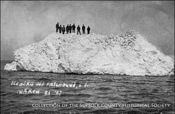 Image copyright Suffolk County Historical Society
Nine Men on an Iceberg, Patchogue, 1907. Image from the Patchogue Postcard Collection of the Suffolk County Historical Society.
Could this year’s bitter cold and snowy winter weather get any worse? The winter of 1907 was probably harsher. In that year, a very large 28-foot-high iceberg broke off the shore of Patchogue and drifted into Great South Bay. This photo from our postcard collection is dated March 21, 1907. The Great South Bay used to freeze over solid almost every winter. Strong winds would push the ice from the bay against the shore and form icebergs like the one shown here.
The recorded history of the village of Patchogue dates back to 1664. The area was a thriving seaport nicknamed Milltown because of the many mills along the Patchogue River and Great South Bay that operated in the 18th, 19th, and 20th centuries,
—————————————————————-
SCHS Photo of the Week: Click Here to Visit Webpage.
Visit: www.suffolkcountyhistoricalsociety.org
To view 2014 Photo of the Week pages click here.
_________________________________________________________
PHOTO OF THE WEEK: Feb. 27, 2015 — FROM THE SCHS LIBRARY ARCHIVES
February is Black History Month!
Samuel Ballton of Greenlawn, 1838-1917
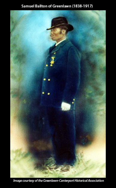 Samuel Ballton (1838-1917): Greenlawn Farmer, Businessman, Pickle King. Image courtesy of the Greenlawn-Centerport Historical Association.
Samuel Ballton, well known as the Pickle King of Greenlawn, was born a slave on a plantation in Virginia. He escaped slavery in the South and subsequently joined a Massachusetts regiment that faced many battles in the Civil War. In 1873, Ballton and his wife Rebecca arrived in Greenlawn, where Ballton made a living as a tenant farmer and then as a sharecropper for Alexander Gardiner, owner of the largest farm in Greenlawn and a descendant of the Gardiner family of the East End of Long Island. It was at this time that Ballton became famous for the record number of cucumbers he produced–1.5 million pickling cucumbers in one season (1899)! He was thus crowned the Pickle King.
Ballton raised funds and began to acquire land near the LIRR tracks in Greenlawn. He built several houses, using former slaves and carpenters from the South to construct them. The 1896 Brooklyn and Long Island Business Directory contained an ad for “Samuel Ballton, real estate agent, Greenlawn, L.I.–Houses and lots for sale in different parts of Long Island.” Remembered as a hardworking entrepreneur who contributed to the economic growth of Greenlawn at the turn of the century, Ballton died in 1917 and was buried in the Huntington Rural Cemetery.
The history of Greenlawn’s Pickle King and pickle industry is kept alive by the Greenlawn-Centerport Historical Association’s Annual Pickle Festival, which this year will take place on September 19 at the John Gardiner Farm in Greenlawn.
—————————————————————–
SCHS Photo of the Week: Click Here to Visit Webpage.
Visit: www.suffolkcountyhistoricalsociety.org
To view 2014 Photo of the Week pages click here.
_________________________________________________________
PHOTO OF THE WEEK: Feb. 20, 2015 — FROM THE SCHS LIBRARY ARCHIVES
February is Black History Month!
Slaves Burying Ground, Orient
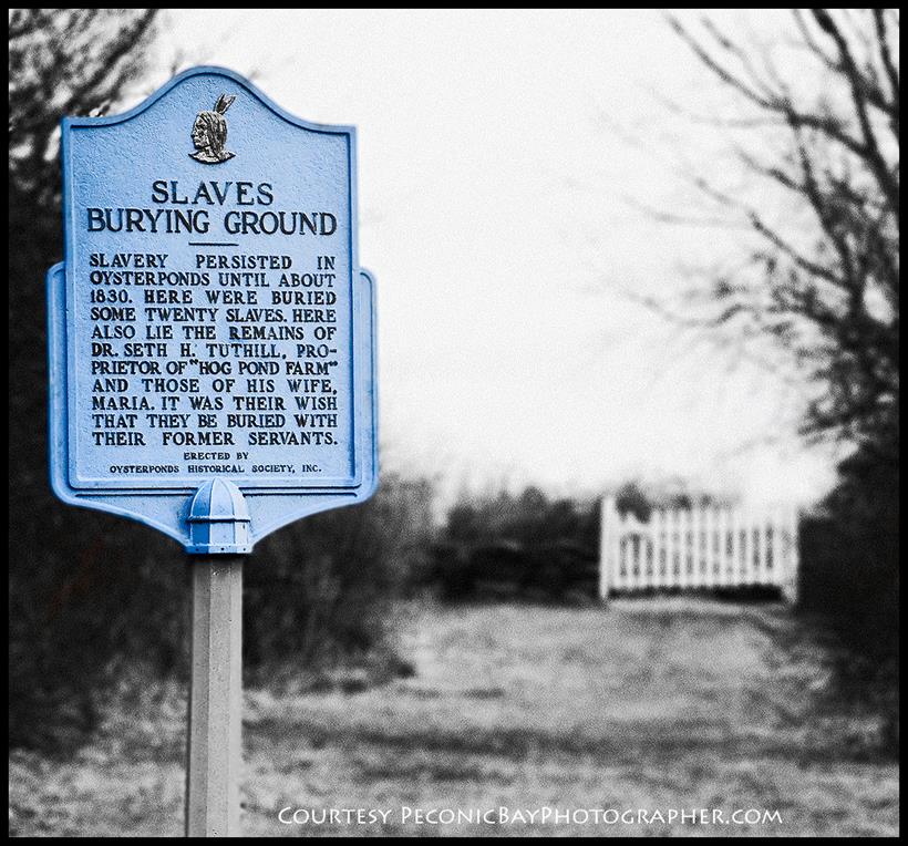
Slaves Burying Ground, Orient. “Slavery persisted in Oysterponds until about 1830,” the marker reads. “Here were buried some twenty slaves. Here also lie the remains of Dr. Seth H. Tuthill, proprietor of ‘Hog Pond Farm,’ and those of his wife, Maria. It was their wish that they be buried with their former servants.” Photo courtesy of PeconicBayPhotographer.com.
This small, picturesque burying ground in Orient near the sea contains only twenty-two burials, but it is quite unusual among slave cemeteries in the United States because in it lies the graves of Seth and Maria Tuthill along with twenty of their slaves.
In the nineteenth century, “it was unthinkable…that slaves be buried with their owners, in cemeteries of white people,” wrote Doris Glover and Jean LaPorte in their Genealogical History of the Tuthill Family. Nonetheless, over the years, the Tuthills formed strong bonds with their slaves and wanted to be buried alongside them. Finding no existing cemeteries willing to accommodate their wishes, the couple set aside a portion of their own property, Hog Pond Farm, for this purpose. Uncut granite bolders were used to mark the graves of the twenty slaves, although some of the markers have gone missing. Maria Tuthill died in 1840, and her husband followed in 1850. The Oysterponds Historical Society now owns and maintains the property, located on a beautiful stretch of Narrow River Road.
——————————————————————
SCHS Photo of the Week: Click Here to Visit Webpage.
Visit: www.suffolkcountyhistoricalsociety.org
To view 2014 Photo of the Week pages click here.
__________________________________________________________
PHOTO OF THE WEEK: Feb. 13, 2015 — FROM THE SCHS LIBRARY ARCHIVES
Valentine’s Day Postcards, Early 1900s

Valentine’s Day Postcards, Early 1900s. From the Holiday and Carleton Kelsey Postcard Collections of the Suffolk County Historical Society.
“I was caught kissing at Greenport, L.I., one of the sweetest girls you ever met” says the 1915 postcard. Sent by Bill of Greenport to Miss Bessie Woodburn of Southampton, its personal message reads: “Dear Friend– How are things in Southampton? Expect to be over soon. — Bill”
While the history of Valentine’s Day is shrouded in mystery, Valentine greetings were popular as far back as the Middle Ages, though written Valentines didn’t begin to appear until after 1400. The oldest known Valentine still in existence today is a poem written in 1415 by Charles, Duke of Orleans, to his wife while he was imprisoned in the Tower of London.
In addition to the United States, Valentine’s Day is celebrated in Canada, Mexico, the United Kingdom, France, and Australia. By the middle of the 18th century, it was common for friends and lovers to exchange small tokens of affection or handwritten Valentines, and by 1900 printed cards and postcards began to replace the handwritten letters due to improvements in printing technology. Also around this time, cheap postage rates contributed to an increase in the popularity of sending Valentine’s Day greetings.
———————————————————–
SCHS Photo of the Week: Click Here to Visit Webpage.
Visit: www.suffolkcountyhistoricalsociety.org
To view 2014 Photo of the Week pages click here.
____________________________________________________
PHOTO OF THE WEEK: Feb. 6, 2015 — FROM THE SCHS LIBRARY ARCHIVES
Pyrrhus Concer from Southampton, 1814-1897
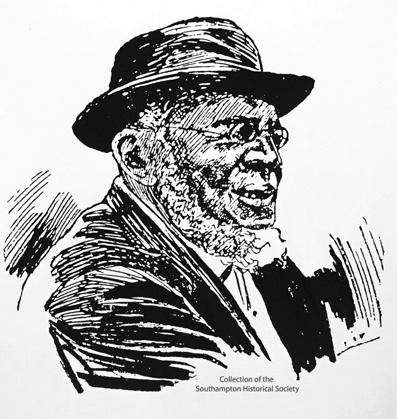 Pyrrhus Concer: Slave, Whaler, & Entrepreneur from Southampton, 1814-1897. From the Collection of the Southampton Historical Museum. Reproduced by permission.
Born a slave in Southampton in 1814, Pyrrhus Concer, as a free man, went whaling at the age of 18. He sailed as a common seaman during his first voyages and then was promoted to boatsteerer, a position of great importance on a whaling ship. The boatsteerer was responsible for guiding the whaleboat toward the targeted whale and for throwing the first harpoon, and then for holding the boat close to the whale while other shipmates killed the whale.
Concer sailed on the famous voyage of the Manhattan in 1848, captained by Mercator Cooper of Southampton, when it picked up several shipwrecked Japanese fishermen in the Pacific Ocean. The Manhattan took those fishermen from Japan home and thus became the first American ship to enter Tokyo Harbor, which at the time was closed to foreign ships. The Japanese were fascinated by Concer, the first person of African heritage they had ever seen, and treated him with curiosity and respect. After retiring from whaling, Concer headed for the goldfields of California for a short time before returning to Southampton, where he operated a ferry service on Lake Agawam.
Concer, who died at the age of 84 in his home at 51 Pond Lane in Southampton Village, left a legacy to the Presbyterian Church of Southampton and a fond memory. His obituary described him as “one of the most respected residents of the village.”
Unfortunately, the historic Pyrrhus Concer home was recently demolished by the current property owners, though efforts are under way to reconstruct the historic building. Click here for more information.
The stone that marks the Southampton grave of Pyrrhus Concer bears this inscription:
Though born a slave
he possessed virtues
without which kings
are but slaves.
——————————————-
SOME PAST PHOTOS OF THE WEEK
The Suffolk County Historical Society’s PHOTO OF THE WEEK Series is created by librarian Wendy Polhemus-Annibell using historic primary source materials from our local history library’s extensive archives. To subscribe, visit our website or send an email request to Wendy at wannibell@schs-museum.org
———————————————————–
SCHS Photo of the Week: Click Here to Visit Webpage.
Visit: www.suffolkcountyhistoricalsociety.org
To view 2014 Photo of the Week pages click here.
____________________________________________________
PHOTO OF THE WEEK: Jan. 30, 2015 — FROM THE SCHS LIBRARY ARCHIVES
Montauk Fishing Club, 1918
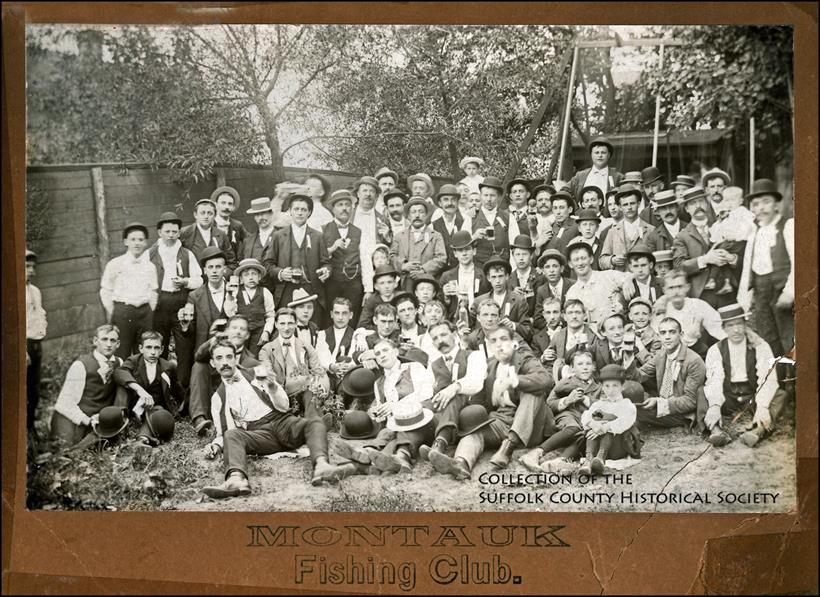
Montauk Fishing Club, 1918. Image from the SCHS East Hampton Pictorial Collection [182.116.1]; copyright © Suffolk County Historical Society. All rights reserved..
Montauk is renowned for its world-class fishing with more saltwater fishing records than any other place on earth. It is also home to the largest commercial and recreational fishing fleet in New York State.
In the 1920s, Montauk was in its rip-roaring prime with daytime fishing and night-time rumrunning. Fishermen could go on the “night shift” and earn ten dollars and a case of liquor for helping unload firewater brought to the docks. Each night a fleet of ships from Nova Scotia, England, or Cuba would lay just beyond the U.S. territorial waters off Montauk, a spot that became known as Rum Row or Rum Line. Dodging coast guard and customs boats, small fishing boats would sneak out of Fort Pond Bay and make a dash for Rum Row, filling up with as much whiskey and rum as they could hold and zig-zagging their way back to Montauk’s shores.
The best-known liquor boat, the Arethusa, was run by William McCoy. Anchored just 12 miles offshore and open for business 24/7, the Arethusa was loaded with Johnny Walker Red and Baccardi. McCoy was well known for selling quality booze at a fair price–and thus, urban legend claims, the expression “the real McCoy” was coined.
———————————————————–
SCHS Photo of the Week: Click Here to Visit Webpage.
Visit: www.suffolkcountyhistoricalsociety.org
To view 2014 Photo of the Week pages click here.
_______________________________________________________
PHOTO OF THE WEEK: Jan. 23, 2015 — FROM THE SCHS LIBRARY ARCHIVES
Northport Harbor, View from Greenlawn, 1903
Northport Harbor, View from Greenlawn, 1903, by Hal B. Fullerton. Image from the Harry T. Tuthill Fullerton Collection [149.7.291], copyright © Suffolk County Historical Society. All rights reserved. To view Fullerton photo, please see link below.
When Dutch explorers came to Northport, the area was already the home of the Matinecocks, who camped along streams and called the area Opcathontyche, meaning “Wading Place Creek.” In 1656, Asharoken, head of the Matinecocks, sold land in the area to settlers in Huntington. At this point the area was called Great Cow Harbor, presumably because of the unusual proximity of cattle pastures to the harbor. After the revolutionary war, Great Cow Harbor grew rapidly.
The name Northport first appears in the town records of 1837, though there is no record of how that name came to be selected. During the War of 1812, the harbor took on one of its most important roles when shipyards began appearing along Bayview Avenue. By 1840, shipbuilding had become Northport’s first major industry. Its most successful shipbuilder was Jesse Carll, who in 1855 set up shop at Bayview Avenue and Main Street, later the site of the village park. Ultimately, Northport turned out more than two hundred sailing vessels by the late 1880s. The historic harbor was also a major center for shellfishing and a terminal for ferries from New York City.
—————————————————————————-
SCHS Photo of the Week: Click Here to Visit Webpage.
Visit: www.suffolkcountyhistoricalsociety.org
To view 2014 Photo of the Week pages click here.
____________________________________________________________________
PHOTO OF THE WEEK: Jan. 16, 2015 — FROM THE SCHS LIBRARY ARCHIVES
Huntington High School Baseball Team, 1911
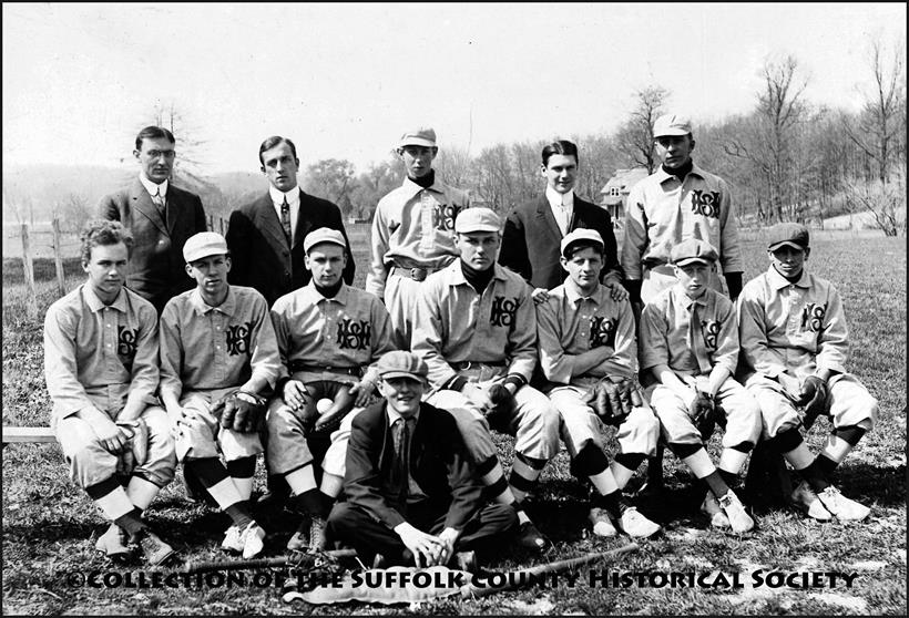 Huntington High School Baseball Team, 1911. Image © Suffolk County Historical Society, from the SCHS A.H. Gallow Collection [205.7.6]. Team members: Simpson, Latham, Hurd, Sammis, Underhill, Trainer, Shakeshaft, Conklin, Galow (team captain), Norden, Grumman, Ketcha, and Ott.
 August Henry Galow (1892-1934), a Huntington native, was a graduate of Huntington HIgh School and the Pratt Institute School of Architecture. He continued his architectural studies at Columbia and New York universities and at the Beaux Arts Institute of Design in New York City. A World War I veteran who served in the U.S. Navy, Galow worked with some of the foremost architects in New York City between 1917 and 1925 while also practicing in Huntington and establishing his own firm. Galow’s architectural achievements on Long Island include the Suffolk County Historical Society building, the Huntington Hotel, the Henry Perkins Hotel, and numerous schools and residences.
—————————————————————————-
SCHS Photo of the Week: Click Here to Visit Webpage.
Visit: www.suffolkcountyhistoricalsociety.org
To view 2014 Photo of the Week pages click here.
____________________________________________________________________
PHOTO OF THE WEEK: Jan. 9, 2015 — FROM THE SCHS LIBRARY ARCHIVES
Prince and Hommel Brick Store After Snowstorm, 1898
Prince and Hommel Brick Store After Snowstorm, Southold, January 14, 1898. Image © Suffolk County Historical Society, from the SCHS Henry W. Prince Collection [B4.F18.121].
In this photo, Fred G. Prince and his father, merchant Henry W. Prince, appear at the far right. The sign above “Oysters” reads: “Fruits & Confectionary, Fresh Roasted Peanuts, Cigars, and Tobacco, Nuts of All Kinds.” An oyster bar was accessed by a staircase to the cellar and was rented by Maynard. At the extreme left is the James B. Fanning house.
In 1862, Henry Wells Prince (1839-1925) was among the first to volunteer for duty in the 127th Regiment of New York Volunteers Company H, which included all men from Southold Town. After the war and until 1870, he traveled throughout the state for the drug firm S.R. Van Duser. Then, in 1874, Henry and his friend G. Frank Hommel built this double brick store with the boundary running right through the middle of its double brick wall. Henry owned the east side next to his “Old Wells House” home and sold a variety of general merchandise in the store. He eventually bought the other half of the building. Henry was active in the Methodist Church, was Town Clerk in 1882, and was President of Southold Savings Bank. About 1915, he turned the business over to his son Frederick and devoted his time to the Finance Committee at the bank. Today the Prince Building is home to the Southold Historical Society.
INFO. SOURCE: Descendants of Captain John Prince of Southold, New York, and Their Place in Local History, compiled by Helen Wright Prince, 1983.
—————————————————————————-
SCHS Photo of the Week: Click Here to Visit Webpage.
Visit: www.suffolkcountyhistoricalsociety.org
To view 2014 Photo of the Week pages click here.
____________________________________________________________________
PHOTO OF THE WEEK: Jan. 2, 2015 — FROM THE SCHS LIBRARY ARCHIVES
Blue Point – Hunters and Shack, 1903
Blue Point – Hunters and Shack, Feb. 1903, by Hal B. Fullerton. Image from the Harry T. Tuthill Fullerton Collection of the Suffolk County Historical Society [149.7.1542]. © Suffolk County Historical Society. All rights reserved. To view this photo, click here.
No one knows for sure how Blue Point got its name. Some speculate that 17th-century baymen named the area after the blue haze they often viewed over this point of land that juts out into the Great South Bay. The Native Americans knew it as Manowtassquot, “land of the basket rush,” after years of harvesting the area’s marshes to make baskets and mats. Deeded to English colonists in 1664, Blue Point was controlled by the Winthrop family until the mid-1700s, when it was sold to Humphrey Avery. Blue Point was a strategic seaport held by the British during the Revolutionary War, a fact known to the rebels who frequently raided British ships docked in the harbor.
Blue Point became a summer resort destination in the 1880s after the Stillman family, members of the Baptist Church, began performing baptisms at their bayside home. So many people began showing up to be baptized that the Stillmans built additional changing rooms outside their home. These evolved into bathhouses where visitors could rent bathing suits for 25 cents each. Stillman’s bathing beach eventually grew to include 600 bathhouses, and other resort hotels followed.
Of course, the Blue Point Oyster, pulled by baymen from the hamlet’s rich oyster beds, became synonymous with the best oysters money could buy. Even Queen Victoria preferred them above any other variety. She only insisted that the rough shells be sanded before they were served to her in Buckingham Palace!
How many quaint hamlets can foister
World fame and renown as their boister?
But our Long Island venue
Adorns the best menu,
Thanks to this mollusk,
The Great Blue Point Oyster!
INFO. SOURCE: Gene Horton, Blue Point Remembered (1982).
—————————————————————————-
SCHS Photo of the Week: Click Here to Visit Webpage.
Visit: www.suffolkcountyhistoricalsociety.org
To view 2014 Photo of the Week pages click here.
___________________________________________________________________